Yellow Rock
Yellow Rock is a prominent landmark off Cottonwood Wash Road, about an hour from Page. If you like photographing patterns and splashes of color you'll love Yellow Rock. Yellow Rock can be seen at a distance from the Paria Movie Set Road, and also from Highway 89. It is not visible from Cottonwood Wash Road. It photographs best close to sunrise, and mid-late afternoon. Yellow Rock faces east - at sunset the good side will be in shadow. If you want to photograph it in the afternoon don't arrive too late. In Kelsey's book Hiking and Exploring the Paria River 5th edition he recommends photographing mid-day, in my opinion this is wrong, color is much better at sunrise.
At 5,500 feet in elevation Yellow Rock is one of the highest points in the area, so if thunderstorm activity is forecast do not visit it.
Other attractions in the area include Castle Rock and Brigham Plains Road. Castle Rock is north of Yellow Rock and can be climbed by going up the ramp on its southeast side. Brigham Plains Road leads to a good overlook of the Cockscomb and Yellow Rock. Brigham Plains Road is steep, narrow, and has dropoffs. It is clay based - do not drive it when wet. A 4x4 is needed when dry. Many people will find this road very uncomfortable to drive.
Directions to Yellow Rock
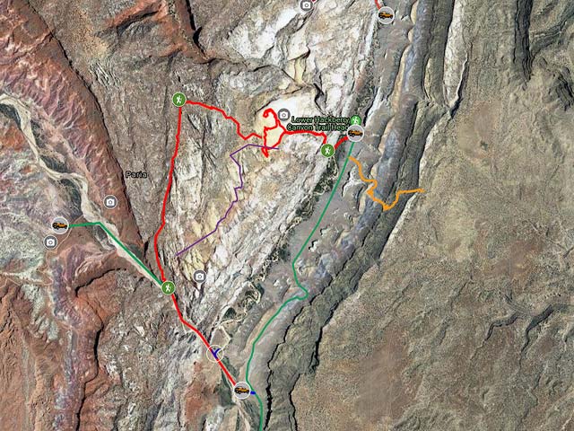
The most direct route up Yellow Rock starts at the signed Hackberry Canyon trailhead just off Cottonwood Wash Road. You can car camp at the trailhead. There are several available sites. You will need a permit from the BLM. Permits are available at the GSENM visitor centers in Escalante or Kanab. Hackberry Canyon trailhead is 14.4 miles north of the intersection of Cottonwood Wash Road and Highway 89 (milepost 17.7 on Hwy 89). The trailhead turnoff on Cottonwood Wash Road is at 37.256672, -111.908830. From the trailhead walk SW and cross Cottonwood Wash which normally has a few inches of water in it. Continue to the first drainage, about .25 miles from the trailhead, and turn to the west. A faint trail goes up the right (north) side of the drainage. There are some cairns. The trail is steep and has loose rock, be careful. A hiking stick may be helpful, especially when going down this trail. Once you reach the top of the cliffs the trail is well cairned and leads you to a location at about the center of Yellow Rocks base. Yellow Rock is easy to climb, explore as you will and return back the same way you came. I've included the track that I took on the map.
Alternatively if you have two cars or you are willing to walk for about 2.7 miles along Cottonwood Wash Road you can do a loop hike. Begin your hike at the Hackberry trailhead. At Yellow Rock proceed to the south side and hike WNW for about 0.7 miles till you reach a cairned trail heading south. The trail is faint and hard to follow so I've included my track from a recent hike. You need to find this trail or you won't be able to get down to the Paria River later in the hike. If you can't find the trail return the way you came. Proceed south along the trail for another two miles and descend to the Paria river. At the river turn downstream (SE) and proceed for a little over one mile to the Box trailhead. You'll need to cross both the Paria River and Cottonwood Wash. At the Box Trailhead pick up your second car and drive north on Cottonwood Wash Road 2.7 miles to complete the loop, or walk this section along the road.
Finally, you can also get to Yellow Rock from the Paria Movie Set. In this way you avoid the steep climb of the direct route. To do so take the Paria Movie Set road (milepost 30.7 on Highway 89) about five miles and park near the Paria River. I cannot give the exact location of where to park as the road crosses some washes near the river and may be impassable, and some of the side roads/tracks have now been closed. It is illegal to cross or drive in the Paria River bed. From your car hike cross country to the river, and then downstream about 1 mile to the cairned trail at 37.237319, -111.938794. From here it is 2.7 miles to Yellow Rock. Round trip this route is about 8 miles long, not including any miles for exploring Yellow Rock.
To view the map in Google Maps please click anywhere on the map above.
- Click to download a KMZ file (Note - in IE Right Click and choose Save Target as).
- Click to download a KML file (Note - KML files do not include custom icons).
- Click to download a GPX file (Note - in IE Right Click and choose Save Target as).
24K Topo Maps
Yellow Rock itself is covered by the Calico Peak USGS 24K map. If you wish to hike in from the Paria Movie Set or The Box you will also need the Five Mile Valley Map. They can be downloaded in a variety of formats by clicking or right clicking below.
| Geo Tiff/Avenza | KMZ | Oruxmaps | KMZ Decollared | Oruxmap Decollared | Avenza Decollared |
| Calico Peak | KMZ | Oruxmap | KMZ Decollared | Oruxmap Decollared | Avenza Decollared |
| Five Mile Valley | KMZ | Oruxmap | KMZ Decollared | Oruxmap Decollared | Avenza Decollared |
| Merge of both maps | NA | NA | KMZ Decollared | Oruxmap Decollared | Avenza Decollared |