White Mesa Arch and surroundings
Leading Lines at White Mesa Arch
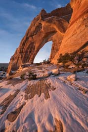
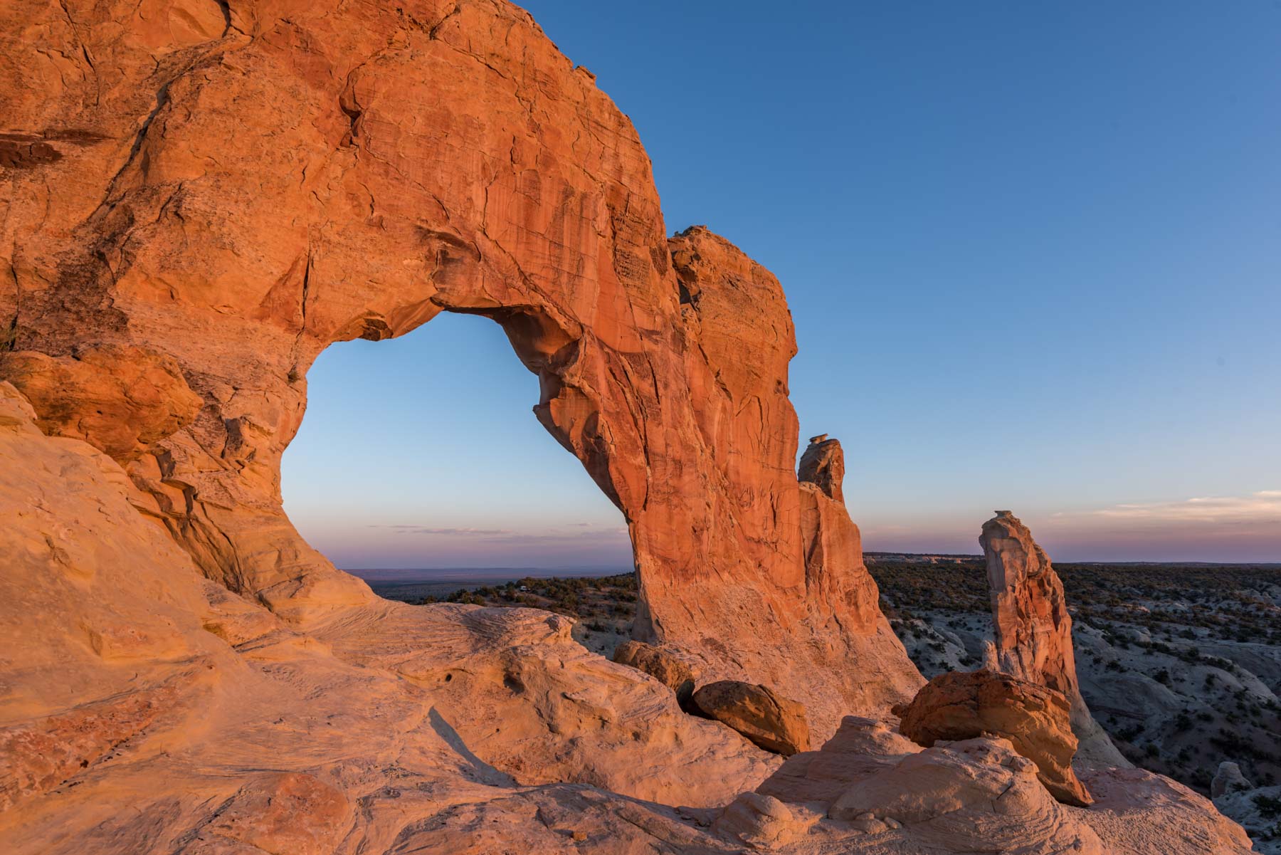
White Mesa Arch is a superb destination in the Navajo Nation. The arch is very large with a span of 53 feet, and a height of 84 feet. The arch is easily viewed from Highway 160. It has a reputation of being hard to reach but if you follow the directions below you should encounter no difficulties. A high clearance vehicle is needed for the last two miles of road.
The arch is best photographed at sunrise all year round. The bench on the arches eastern side has sandstone lines that lead you right into the arch. For about ten minutes after sunrise the arch takes on a red glow. If you plan to shoot the arch arrive at the parking area at least 30 minutes before sunrise. This will give you time to hike to the bench on the eastern side of the arch, or to shoot in the blue hour.
White Mesa Arch opens to the southwest and frames the full moon during parts of the year. You will not be able to shoot longer than 35mm from the superb east side bench, but can shoot longer if you exclude the bench. I shot at 150mm from just below the dirt road to the arches east, as shown on the map below. You will not be able to include the leading lines on the bench when shooting from here. To include the full moon in the arches opening at sunrise you need to shoot in June or early July. The June full moon is known as the "Strawberry Moon", as its presence was a signal to the Algonquin tribe that it was time to start harvesting strawberries. To capture the full moon inside the arch go as close to the summer solstice as possible, one-two days after the Strawberry moon.
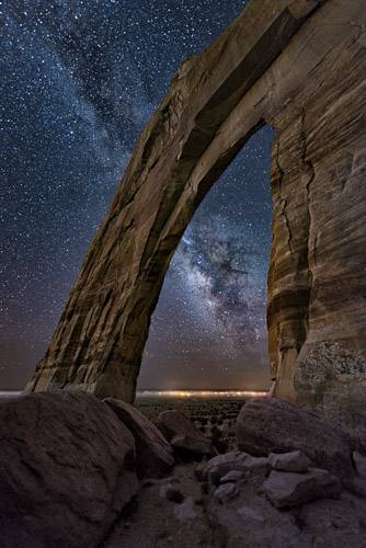
Sunset full moon images are also possible. This photo by David Muench was shot at sunset from its southwestern side. Muench's image was probably taken in late fall or early winter. From June through August it is possible to shoot the Milky Way through the arch as shown here, shot mid-August around 9PM AZ time.
White Mesa arch falls off sharply to the west and you cannot walk from one side of the arch to the other. Although there are good sandstone patterns on the arches southwestern side White Mesa Arch is in shadow at sunset for most of the year, excepting the winter solstice. If you are able to visit in December or January shoot an hour or so before sunset for best light. The arch will be front lit and you'll need to work around your shadow at this time of year.
You will need an "ultra" wide angle lens to get the best pictures of the arch. Many of the images in my gallery were shot at 14mm on a full frame camera and there were times when I wished I could go wider. A panorama head and rails would make a good alternative. If you shoot with a panorama rig use one that allows for rotations both vertically and horizontally.
Surrounding Area

Margaret Arch
Navajo Stand Rock
While in the White Mesa Arch area consider visiting Navajo Stand Rock and Margaret Arch. Navajo Stand Rock is beautifully captured in this Tom Till image shot at sunset. Sunrise also works, as seen in my photos here.
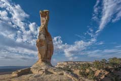
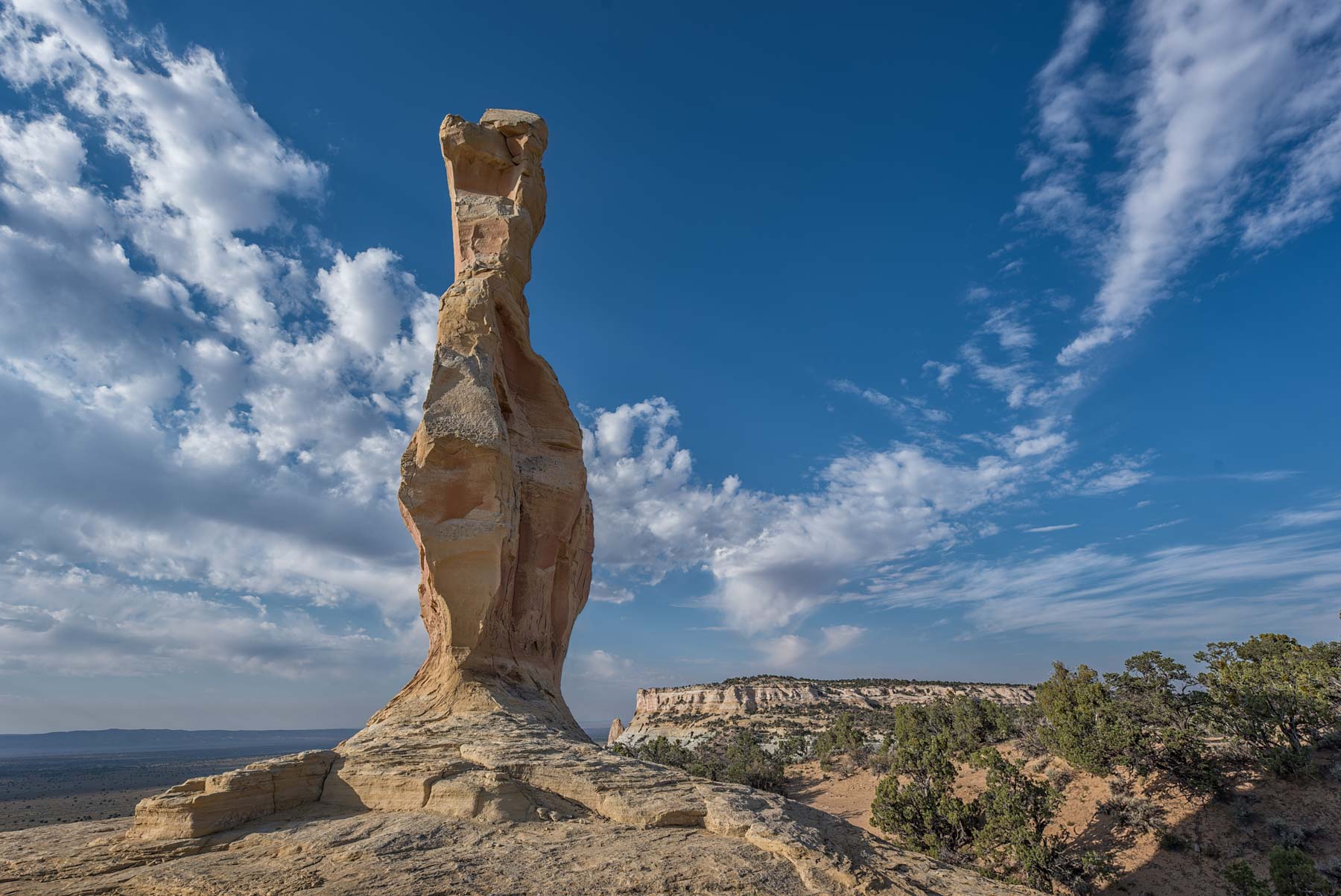
Margaret Arch was "discovered" by photographer, US Senator, and presidential candidate Barry Goldwater. It is named after his wife Margaret. The Navajo reportedly placed a plaque officially naming it "Margaret Arch" at its base when it was dedicated. On a visit in June of 2016 I could not locate this plaque. I believe it either never existed or was removed. Margaret Arch has several other names. It is also known as Catherine Arch (origin unknown). It appears on the USGS Square Butte as Window Rock. The arch was renamed by the Navajo Tribal Council in 1988 as Margaret Arch despite considerable controversy. Margaret Arch is its official name per the USGS Bureau of Geographic Names.
Margaret Arch opens to the southeast. The northwest side of the arch is the most photogenic. The arch is best shot near sunset. Unfortunately on my first visit I was there mid-morning, and could not hang out as temperatures reached 100 degrees that day. Since Margaret faces southeast Milky Way images should work well during late spring and summer. My gallery includes late day images taken from both the southeast and northwest sides of the arch.
Margaret Arch is very rarely visited. The only close-up photo I could find was by arch hunter Ron Blekicki. While the arch is unimposing from a distance, when shot from close up it is very beautiful and is certainly worth the difficulty of a sunset visit.
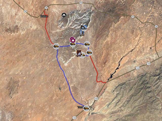
Travel directions to Navajo Stand Rock and Margaret Arch are shown on the map below. The road shown to Margaret Arch takes you to an overlook of the arch. There is a deep canyon between this overlook and the arch. From the Margaret Arch overlook it is a two mile round trip hike to the arch. There is no trail so I have shown my route on the map below. From the Margaret Arch "trailhead" continue north down the very steep sandy slope to the canyon below. Once in the canyon follow the wash in a west-southwest direction for about .3 miles till you reach a small sand dune to your right. Some bushwhacking will be needed while in the canyon. Proceed up the sand dune in a northeast direction to a ridge. Continue in a northeast direction following the ridge line to the arch. It is easy to scramble up to the arch via its left side and you can shoot from either side of the arch.
Navajo Stand Rock is much easier to get to. It is at the end of a dirt road. No hiking needed. Some people park within ten feet of the hoodoo and have left tire tracks which need to be cloned out. Please park away from the rock.
Directions to White Mesa Arch
From Page drive south on Highway 89 until you reach the intersection with route 160 (road to Tuba City). Drive 32.2 miles on Route 160 to the intersection with Indian Route 21 (GPS location 36.31943 N, 110.94745 W). Take paved Indian Route 21 14.4 miles to (36.4949 N, 111.05358 W) and turn right onto Indian Route 6260. Take Indian Route 6260 6.2 miles to (36.50019 N, 110.94505 W) and turn right. Stay on Indian Route 6260 for 1.7 miles to (36.47723 N, 110.93675 W) and turn right onto a good dirt road. After 1.6 miles you will reach a farm house at (36.469649 N, 110.961304 W), pass it on the left. Continue 0.5 miles to an open area and park at ( 36.472935 N, 110.970187 W). You will need a high clearance vehicle to drive the last two miles. The arch itself is clearly visible to the northwest. The east side of the arch can be reached via a short hike. I've shown the route on the map.
Permits
White Mesa Arch, Navajo Stand Rock, and Margaret Arch are all part of the Navajo Nation. As of Sept. 2014 you cannot get a permit to visit them. You may be able to get the permission of local Navajo leaseholders to visit the area, as I did on my last few visits.
Google Map of the area
To view the map in Google Maps please click anywhere on the map above.
- Click to download a KMZ file (Note - in IE Right Click and choose Save Target as)
- Click to download a KML file (Note - KML files do not include custom icons)
- Click to download a GPX file (Note - in IE Right Click and choose Save Target as)
USGS 24K Topo Maps
Amazingly the topo map White Mesa Arch covers White Mesa Arch. Navajo Stand Rock and Margaret Arch are on the Square Butte topo map to the north. Both maps together with a merged map can be downloaded in a variety of formats by clicking or right-clicking below:
| Geo Tiff/Avenza | KMZ | Oruxmaps | KMZ Decollared | Oruxmap Decollared | Avenza Decollared |
| Square Butte Quad | KMZ | Oruxmap | KMZ Decollared | Oruxmap Decollared | Avenza Decollared |
| White Mesa Arch | KMZ | Oruxmap | KMZ Decollared | Oruxmap Decollared | Avenza Decollared |
| Merge of both maps | NA | NA | KMZ Decollared | Oruxmap Decollared | Avenza Decollared |
