Around Kanab
Inchworm Arch
Inchworm Arch is an appropriately named arch about ten road miles from Johnson Canyon Road. The arch has two openings and is best photographed near sunrise. Near the winter solstice first light should be just after dawn, during the rest of the year it will take some time for the sun to rise above a nearby rock formation to the east.
Inchworm Arch can be accessed by a 4x4 road starting at the Nephi Pasture Staging Area off Johnson Canyon Road. The map below shows the drive from Johnson Canyon Road. While a 4x4 is needed the drive is relatively easy.
Following the drive to the trailhead there is a short hike of about .2 miles. The well defined trail starts at the south end of the parking area.
Red Canyon
Red Canyon is a slot canyon ten miles north of Kanab. It should not be confused with the Red Canyon on Highway 12 near Bryce Canyon. Red Canyon is also known as Peekaboo Canyon. If you have a high clearance 4WD vehicle the easiest way to visit Red Canyon is by car. From the intersection of Main Street and Highway 89 in Kanab drive 8.9 miles north on Highway 89. Turn right onto Angel Canyon Road and drive .2 miles and turn left onto Route 102M. Follow 102M 1.1 miles to its end and bear right onto Route 102 (Red Slot Canyon). One mile in Red Slot Canyon road goes down a steep sand dune where people routinely get stuck. The area is labeled "The Sand Hills" on the USGS White Tower topo map. Have a shovel with you and air down if needed. Continue 2.2 miles to the sandy Red Canyon drainage and turn left. Continue in the drainage .8 miles to the mouth of Red Canyon. Red Canyon has two short slots. They are best shot good color mid-day when they have good color. The rock itself is not as finely textured as the Navajo Sandstone in the Page Slots but Red Canyon is not nearly as crowded.
Heart Vein
Heart Vein is a slot canyon near Mount Carmel Junction. It is also called Upper Red Cave. There is another slot canyon called Lower Red Cave one mile southwest of Upper Red Cave. Upper Red Cave is the more photogenic of the two and is not technical. Upper Red Cave has several three to eight foot climbs in it and will be a difficult go for most. While it is on BLM land access requires you drive cross private property. The road to the slot has a gate on it which is usually locked. When I went to Upper Red Cave I used a local guide Jim Anderson who had a key to the gate. He also brought a telescoping ladder to help with the many obstacles in the canyon. Jim can be reached at maddog154@hotmail.com or at +1 435 689-0621. I highly recommend him.
Both Lower and Upper Red Caves and Red Canyon drain the same high country. The Red Cave drainages flow into the East Fork of the Virgin River, while Red Canyon drains south into Kanab Creek. The East Fork of the Virgin River continues southwest and joins the Virgin River south of Springdale. Kanab Creek continues south and joins the Colorado River at the Kanab Rapids.
The Flag Point Dinosaur Track Site and Pictographs
Since rock art sites are sometimes vandalized I have decided not to publish the exact location and directions to the tracks and pictographs at this time. I am willing to send you directions if you provide me with your email address and agree not to publish the location of the tracks on the web. Your email address will not be shared with others or used for marketing purposes. In the event of vandalism at the site it may be shared with US or local law enforcement. A request form for directions can be found here.
If you are going to visit the tracksite keep the following in mind:
- Rock images, potsherds or any artifacts are important traces of the past. Removal or desecration is illegal. Never camp in alcoves or cultural sites. If you witness cultural theft or vandalism, call the crime hotline at 1-800-227-7286. A minimum $250.00 reward is offered for information leading to the arrest and conviction of any person violating cultural resource laws.
- Keep the stories in place. Collection of rocks, bones or fossils is illegal within the Monument except for antlers or horns as provided for under UDWR regulations.
- Graffiti on any rock surface offends, vandalizes and is illegal.
The Great Chamber
The Great Chamber, also known as Cutler Point, contains easily damaged rock fins. Please tread carefully. The Drive to The Great Chamber begins on Johnson Canyon Road 9.2 miles east of the main intersection in Kanab. At the Johnson Canyon intersection with Highway 89 turn left and drive 7.8 miles on Johnson Canyon Road. Turn left. There is a large parking area here. You'll need a high clearance 4x4 to continue. From the parking area, drive 3.8 miles west and make a sharp right turn. There's deep sand, so you may want to air down. Continue .67 miles and turn left. Continue .54 miles and turn right. Continue 3.19 miles to the trailhead for the short hike to The Great Chamber. The trailhead is just before the road ends in a turnaround. As of my last trip several years ago, there was no official trail to The Great Chamber, but there were many social trails. Head east up the sand dune for 0.3 miles till you come to a large alcove which is your destination. If you do not have a 4x4 Action Photo Tours, with whom I have no relationship, runs tours to the Great Chamber. Other tour companies go there as well, and the area is becoming crowded. Expect the sand dune within the alcove to have many footprints. These may be hard to remove in Photoshop.
The Kanab Hoodoos
The Kanab Hoodoos are a spectacular set of red hoodoos concentrated in a small area. The hoodoos are on very thin bases so I have decided not to publish their location at this time. The hoodoos are best shot early in the morning or in the blue hour. Early to mid-afternoon will also work.
Here is an overview map showing the various attractions in the Kanab area:
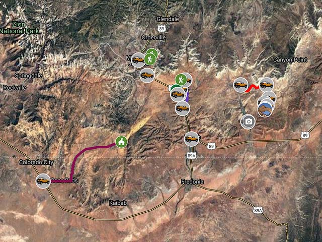
To view the map in Google Maps please click anywhere on the map above.
- Click to download a KMZ file (Note - in IE Right Click and choose Save Target as)
- Click to download a KML file (Note - KML files do not include custom icons)
- Click to download a GPX file (Note - in IE Right Click and choose Save Target as)
Bureau of Land Management Maps
The BLM provides georeferenced maps for much of the Western US. The maps show OHV roads, wild and scenic rivers, and land ownership. Maps are in GeoPDF format and can be freely downloaded. The BLM Map Kanab South covers the attractions above. The Kanab BLM maps can be downloaded in a variety of formats by clicking or right-clicking below:| Geo PDF | Geo Tiff / Avenza | KMZ Decollared | Oruxmap Decollared | Geo Tiff / Avenza Decollared |
| Kanab South | Geo Tiff | KMZ Decollared | Oruxmap Decollared | Avenza Decollared |
| Kanab North | Geo Tiff | KMZ Decollared | Oruxmap Decollared | Avenza Decollared |