Twentymile Wash Tracksite
The Twentymile Wash Dinosaur Tracksite is in the Grand Staircase Escalante National Monument and is about twenty miles from the town of Escalante. Over 1,000 tracks are present at the site. Large bipedal dinosaurs made the tracks. The tracks are about twenty inches long and both trackways and tail drags are present. Tail drags are rarely seen as dinosaurs used their tails primarily for balance and did not rest on them. The dinosaur tracks at Twentymile Wash are not indented but can be identified as darker fillings on the underlying sandstone. The tracks are found in the Escalante member of Entrada sandstone. This member has a white to light gray appearance with a very slight yellow to green tint and is quite photogenic. There are a great many cavities present in the sandstone which add to the interest. More information on the tracksite can be found here.
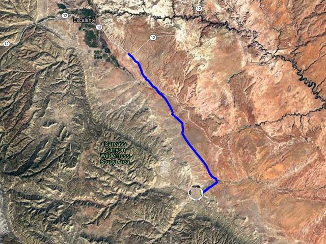
Getting there
I suggest you stay in either Escalante or Boulder, Utah, or car camp in the Grand Staircase Escalante National Monument. You'll need a free permit from the BLM to camp in the area. It is illegal to camp at nearby Devil's Garden. Here are directions from Escalante:
- From the town of Escalante continue about five miles east on Highway 12 and turn south / right on Hole in the Rock Road (BLM 200).
- After 12.2 miles you will pass a road signed Devil's Garden on the right.
- Continue an additional 2.1 miles and turn west / right on Left Hand Collet Road (BLM 230).
- Continue SW on Left Hand Collet Road (BLM 230) 2.3 miles to a dirt road heading to the right (north).
- If you have a high clearance vehicle continue .4 miles or so to a small parking area and trailhead register and park. If you do not have a high clearance vehicle park on BLM 230 and walk the .4 miles to the trailhead.
- The tracks are located due north of the small parking area. You will need to ascend the Entrada sandstone. An easy place to do this is about .1 miles west of the trailhead. Once on the sandstone continue north, the tracks are on the uppermost level just before the small vegetated rise.
Shooting Tips
You may want to bring a spray bottle filled with water. If you wet the tracks they will be more visible. It is illegal to excavate/remove tracks from the site. Do not sweep sand off the tracks, or make rubbings or castings of them. The site will photograph well within a few hours of both sunrise and sunset. The site is quite close to Devil's Garden which could be photographed on the same day.
Maps
Here is a Google map of the Twentymile Wash Megatrackway:
To view the map in Google Maps please click anywhere on the map above.
- Click to download a KMZ file (Note - in IE Right Click and choose Save Target as)
- Click to download a KML file (Note - KML files do not include custom icons)
- Click to download a GPX file (Note - in IE Right Click and choose Save Target as)
USGS 24K Topo Maps
Seep Flat contains contains the entire area where the dinosaur tracks are, and also clearly shows the Left and Right Hand Collet Canyons and the last road to the tracks. As is now my practice I have provided GeoTIFF, KMZ, and Oruxmap formatted files, click or right click below to download.
| Geo Tiff/Avenza | KMZ | Oruxmaps | KMZ Decollared | Oruxmap Decollared | Avenza Decollared |
| Seep Flat | KMZ | Oruxmap | KMZ Decollared | Oruxmap Decollared | Avenza Decollared |