Southeast Arizona
Ghost towns
Southeast Arizona has a rich history beginning with the Hohokam who occupied the area for nearly 4,000 years. 500 years ago the Spanish explored the area in search of gold, and about 150 years ago the Apache Wars began. The apaches defended their land against miners, ranchers, and merchants and adventurers on their way to California.
Tombstone is the most famous of the southeast Arizona mining towns. It is now so commercialized that good photography is hard to find there. You will do better exploring the lesser known ghost towns along the Ghost Town Trail and Fort Bowie.
The Ghost Town Trail
The Ghost Town Trail is a largely unpaved road connecting three abandoned mining towns. The trail is accessible from the north where it connects with US 191, or from Tombstone.
The southernmost ghost town on the trail is Gleeson. To get to Gleeson from the OK Corral in Tombstone take US80 east for 0.7 miles and turn left onto N Camino San Rafael. Take N Camino San Rafael 1.1 miles to E Gleeson Road and turn right. Continue 14.3 miles to the intersection with N High Lonesome Rd which is the center of the Gleeson town.
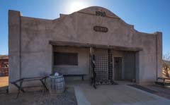
At its peak Gleeson had about 1,000 people living there. Copper was the primary metal mined until it played out when the veins ran into a layer of limestone. There are just a few ruins remaining today. The restored jail, built in 1910, is very photogenic and is best photographed at sunrise. Unfortunately there is a life-size wood cutout of a laconic cowboy bolted to the front of the jail which ruins the historical mood. The photogenic interior of the jail, now a museum, can be toured on the first Saturday of each month from 9AM to 4PM. Other buildings in Gleeson include the foundations of the old schoolhouse just south of the jail, Joe Bono's mercantile and bar, and the hospital. The Gleeson Jail is owned by Joe Bono, the son of the Joe Bono who owned the General Store diagonally across the street. Before the Gleeson jail was built prisoners were chained to an oak tree 200 feet east of Joe Bono's store. You can still see the chain looped around the tree that was used to secure prisoners. Other Gleeson attractions include various copper mines and the Gleeson cemetery.
Continuing north along the Ghost Town Trail one arrives at the town of Courtland. At its heyday Courtland's population was 2,000. Today very little remains except for the jail which is covered in graffiti. The jail had two cells each with a sink and toilet. South of the town are a few foundations including the Great Western Mining office and an old store. West of the jail is a photogenic copper processing plant that was in operation in the 1960s.

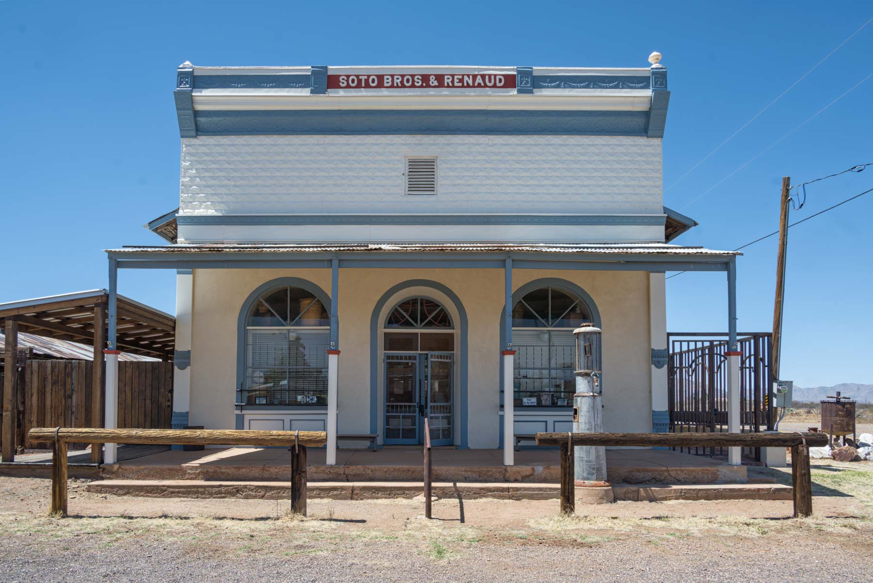
The Ghost Town trail finishes at its north end in the town of Pearce. Pearce had a population of 1,500. Pearce was founded in 1893 and abandoned in 1930 when the silver mines had played out. The current population of Pearce is about 15 people. The primary draw in Pearce is the pristine Soto Brothers and Renaud store / museum which was built in 1896. The store is currently for sale at $944,000. Other attractions include the old Pearce Jail, Our Lady of Victory Catholic Church, and the Post Office. The Catholic Church was built in 1893 and is on the National Register of Historic Places. The Pearce Jail and the-Soto Brothers and Renaud store are best photographed at sunrise. The town cemetery is worth visiting. Reportedly Abraham Lincoln's bodyguard is buried there (reference needed).
Fort Bowie
Fort Bowie was an outpost of the US army established in 1862 following the Battle of Apache Pass. At this battle Cochise, a Chiricahuan Apache, fought a pitched battle against the US Army. A peace treaty between the Chiricahuan Apaches and the US Army was signed in 1872 and Cochise retired to the Chiricahuan Reservation. Following Cochise' death of natural causes in 1874 Geronimo began a series of raids along the US Mexico border. Fort Bowie was the center of the war against Geronimo. Geronimo surrendered to the US Army in 1886 ending the Indian Wars. Fort Bowie was abandoned in 1894.
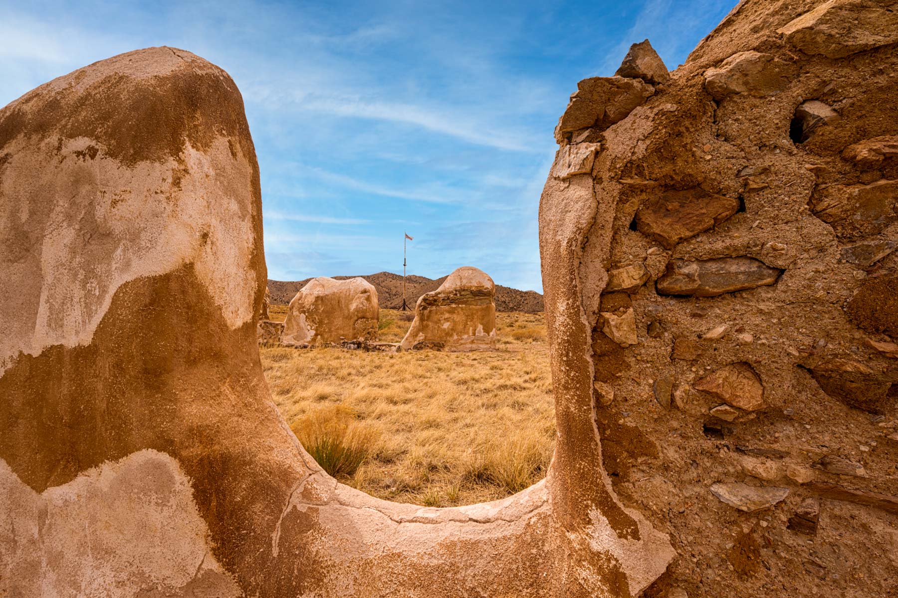
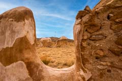
Fort Bowie is now a National Historic Landmark. While only some of the adobe walls of the fort remain today they are quite photogenic at sunrise and sunset when they take on a rich gold color. Mid-day they are gray to tan in color and are unremarkable. With its many walls and angles Fort Bowie is a great place to practice composition technique.
Fort Bowie is, unfortunately, only open from sunrise to sunset. At night the ruins would be excellent foreground for the Milky Way. It may be possible, for a fee, to get a special use permit allowing night time shooting.
Getting to the fort involves an easy three mile round trip hike. If you are limited in your ability to hike you can arrange with the visitor center to drive in instead. Call the Fort Bowie Visitor Center at 520 847-2500 ext 25 for information on driving in. Fort Bowie's "busy" season is March but even then it only gets about 50 visitors per day. In the summer it only gets about ten visitors each day.
Other Locations
Other locations you should visit in southeast Arizona include magnificent Chiricahua National Monument, Kartchner Caverns, the Fairbank Schoolhouse, Whitewater Draw Wildlife area, the Amerind Museum, and Aravaipa Canyon. Unfortunately the Amerind Museum does not allow photography inside the museum or gallery. Kartchner Caverns only allows photography on their photo tours given on the third Saturday of each month. As of 2021 the costs of the photo tour is $125 per person and reservations are required. From November to February there can be as many as 20,000 sandhill cranes at the Whitewater Draw Wildlife area. Aravaipa Canyon is best late November when the cottonwoods are changing; make reservations on recreation.gov early. The west trailhead is more accessible than the east one. The Fairbank Schoolhouse is about ten miles west of Tombstone and is only open from Friday through Sunday. More information on the above locations will be forthcoming.
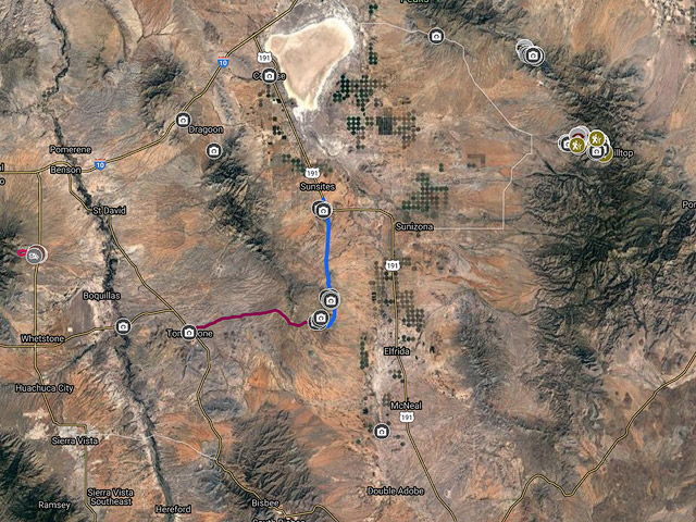
Google Map of Southeast Arizona
The following map shows many of the attractions in southeast Arizona.
To view the map in Google Maps please click anywhere on the map above.
- Click to download a KMZ file (Note - in IE Right Click and choose Save Target as)
- Click to download a KML file (Note - in IE Right Click and choose Save Target as)
- Click to download a GPX file (Note - in IE Right Click and choose Save Target as)
USGS 24K Topo Maps
The Ghost Town Trail
Three maps cover the Ghost Town Trail
| Geo Tiff/Avenza | KMZ | Oruxmaps | KMZ Decollared | Oruxmap Decollared | Avenza Decollared |
| Outlaw Mountain | KMZ | Oruxmap | KMZ Decollared | Oruxmap Decollared | Avenza Decollared |
| Pearce | KMZ | Oruxmap | KMZ Decollared | Oruxmap Decollared | Avenza Decollared |
| Turquoise Mountain | KMZ | Oruxmap | KMZ Decollared | Oruxmap Decollared | Avenza Decollared |
| Map of the entire area | NA | NA | KMZ Decollared | Oruxmap Decollared | Avenza Decollared |
Fort Bowie
A single map covers Fort Bowie
| Geo Tiff/Avenza | KMZ | Oruxmaps | KMZ Decollared | Oruxmap Decollared | Avenza Decollared |
| Fort Bowie | KMZ | Oruxmap | KMZ Decollared | Oruxmap Decollared | Avenza Decollared |
Chiricahua National Monument
Two maps cover Chiricahua National Monument
| Geo Tiff/Avenza | KMZ | Oruxmaps | KMZ Decollared | Oruxmap Decollared | Avenza Decollared |
| Cochise Head | KMZ | Oruxmap | KMZ Decollared | Oruxmap Decollared | Avenza Decollared |
| Rustler Park | KMZ | Oruxmap | KMZ Decollared | Oruxmap Decollared | Avenza Decollared |
| Map of the entire area | NA | NA | KMZ Decollared | Oruxmap Decollared | Avenza Decollared |