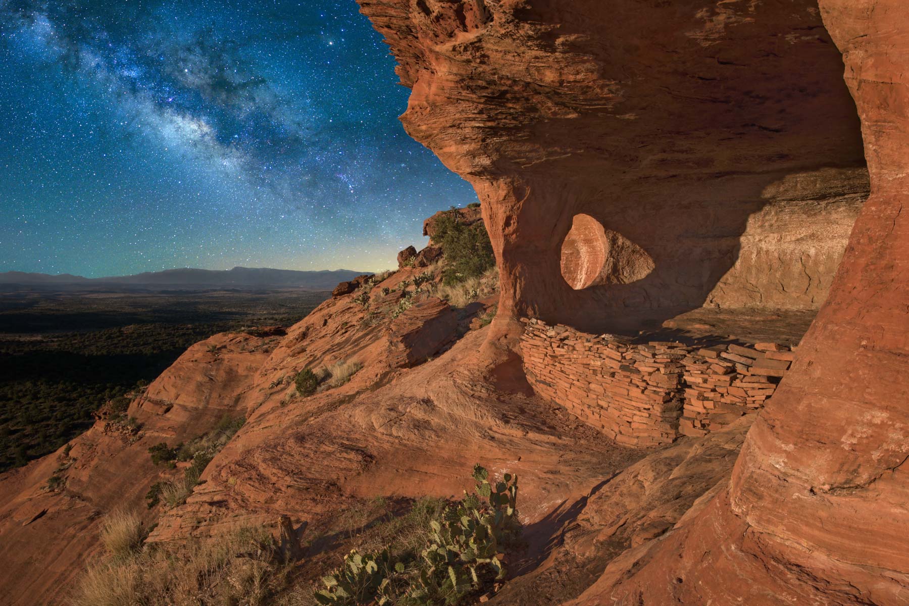
Sedona
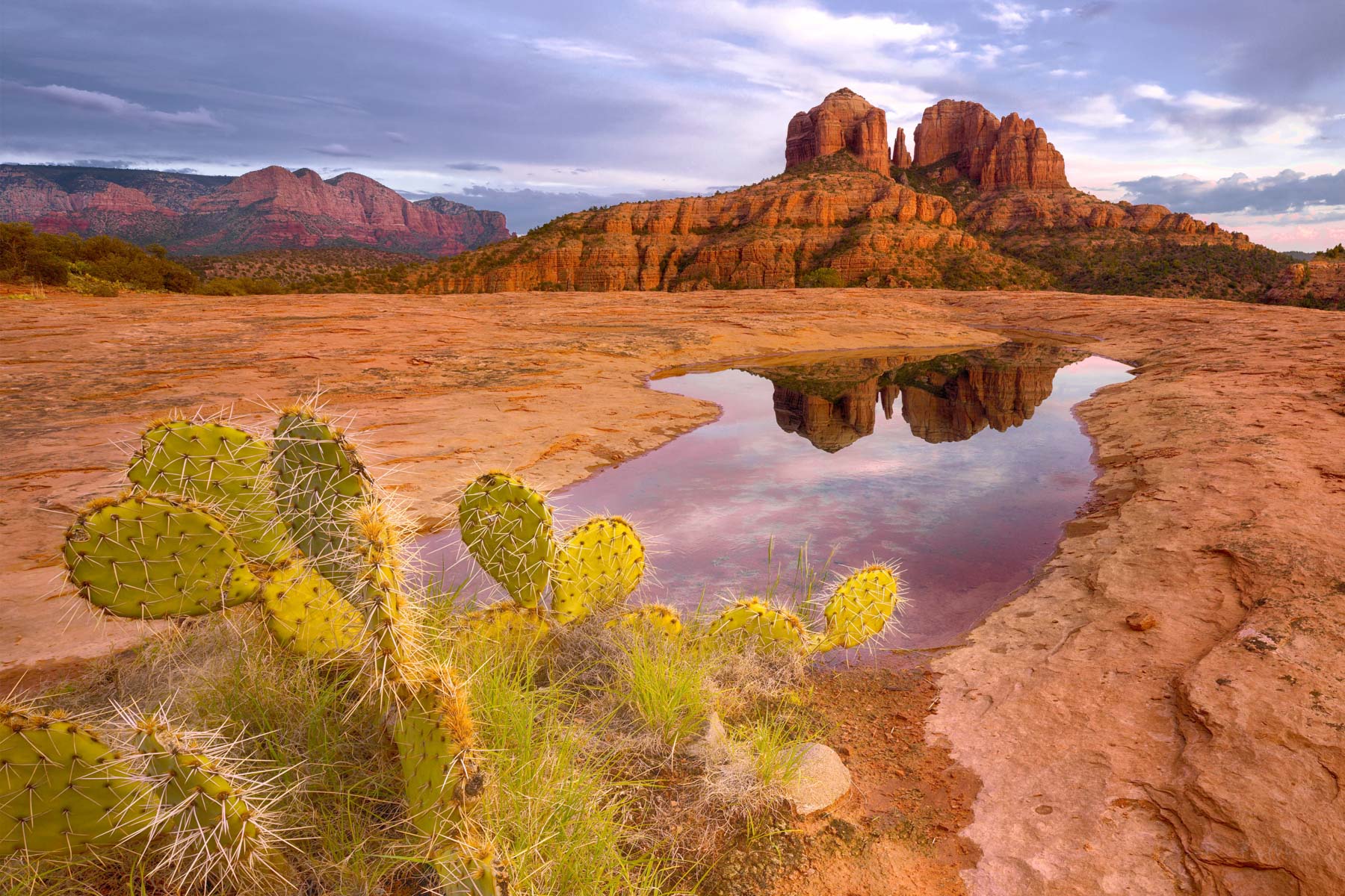
Google Map of Sedona Landmarks and Trails
To view the map in Google Maps please click anywhere on the map above.
- Click to download a KMZ file (Note - in IE Right Click and choose Save Target as)
- Click to download a KML file (Note - KML files do not include custom icons)
- Click to download a GPX file (Note - in IE Right Click and choose Save Target as)
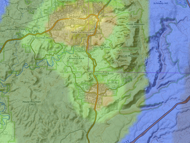
Caltopo Map of Sedona
In addition to the Google Map of Sedona, I have added a Caltopo Map. Caltopo maps show land ownership, which is important if you plan to boondock. You do not want to camp on private land; US Forest Service, NPS, and BLM camping regulations are often different. Caltopo maps are preferable for off-trail hiking since they show ten feet elevation contours and terrain slope shading. Caltopo maps can also show other map sources as layers. Openstreetmap, US Forest Service Maps, and USGS topo maps are available. Openstreetmap is particularly useful as it often includes additional trails and POIs, such as the location of ruins. Caltopo maps can also show sun shading, 24-hour low and high temperatures, precipitation, wind plots, and the air quality index. Pro users can see current temperature, precipitation, wind, snow-pack, and air quality index on the map.
Dark Sky Map of Sedona
The following map from darksitefinder.com gives a rough idea of how dark the skies are in the Sedona area. Click on the map below to zoom in or out or change the base layer:
The map contains 15 colors. The Milky Way is invisible in the white, light gray, and red areas, visible but washed out in the yellow and orange areas, shows the Milky Way's structure in the green and blue areas, and in the black area, light from the Milky Way center casts shadows. Here's more information about how to interpret the colors on the map. This information comes from handprint.com:

Sedona Area Roads
The National Forest Service publishes Coconino National Forest road maps. All legal roads within the National Forest are shown on the maps. Other gravel/dirt roads in the National Forest are closed. You may be subject to a fine if you are found on them. Three color maps are available: an overall map, a north area map, and a south area map. The south area map includes Sedona and the Village of Oak Creek. Here are the maps in digital format; only uncollared maps are available as the legends contain essential information:
| Map in Geo Tiff Format | KMZ Format | Oruxmaps Format |
| Coconino National Forest | KMZ | Oruxmap |
| North Coconino National Forest | KMZ | Oruxmap |
| South Coconino National Forest | KMZ | Oruxmap |
Sedona Trails
The tables below contain KML and GPX routes for over 130 hikes. I have divided the hikes into three groups: those north of Highway 89A, those east of Highway 179, and those west of Highway 179. A few trails cross Highway 179; in that case, I put the trail in the section where most of the trail lies. Many trails are out and back, but often, one can combine several trails to produce a loop. Alternatively, if two vehicles are available, some great one-way hikes can be constructed by combining several trails. Hiking distances below are one-way for out-and-back trails and total round-trip for loop trails. Most trails are well-defined and easy to follow, but we suggest you use a GPS to track where you are and how to get back to civilization. Remember - "The wilderness is not your friend." You could die if you get lost on some of the less trafficked trails. A few routes, such as the hike to the Huckaby Windows, are off-trail and can be steep and exposed. A fall could be fatal. The Off-trail routes included are approximate; use your own judgment as to the best lines to follow.
The final column shows whether it is legal to mountain bike fly a drone over the trail. Mountain bikes and drones are forbidden in designated wilderness areas.
To use the information below, first select a hike using a different source, such as the book "Great Sedona Hikes 4th edition" by Bill Bohan and David Butler and find the corresponding trail (or trails) below. Download either a KML or GPX file to your GPS or phone. You can follow the trail on your GPS / phone as you hike. You can also download a KML file to your PC or MAC and view it in Google Earth. In Google Earth, 3D views are available, and you can see an elevation profile by right-clicking on a trail. Caltopo shows ten-foot elevation lines and slope angle shading to help you understand the terrain you will be hiking on.
Trails East of Highway 179
Some trails east of Highway 179 are in the Munds Mountain Wilderness. Courthouse Buttes and Bell Rock lie in this wilderness; you cannot fly a drone over them. You can mountain bike or fly on the trails near them, however. The area east of Schnebly Hill Road and all of Munds Mountain and Lee Mountain is in this wilderness area.
| Trail | Miles | Download a KML | Download a GPX | Drones/Bikes Allowed |
| Baby Bell Trail | 0.25 | KML | GPX | Yes |
| Bail Trail | 0.35 | KML | GPX | Yes |
| Bell Rock Access Trail | 0.15 | KML | GPX | Yes |
| Bell Rock Trail | 3.6 | KML | GPX | Yes |
| Big Park Loop Trail | 1.5 | KML | GPX | Yes |
| Big Park Loop Connecting Trail | 0.1 | KML | GPX | Yes |
| Broken Arrow Trail | 1.5 | KML | GPX | Yes |
| Chapel Trail | 0.7 | KML | GPX | Yes |
| Courthouse Butte Loop Trail | 2.4 | KML | GPX | Partial |
| Hangover Trail | 3.8 | KML | GPX | Yes |
| High on the Hog Trail | 0.4 | KML | GPX | Yes |
| Hog Heaven Trail | 0.9 | KML | GPX | Yes |
| Hog Wash Trail | 1.5 | KML | GPX | Yes |
| Hot Loop Connector | 0.8 | KML | GPX | Yes |
| Hot Loop Trail | 12 | KML | GPX | No |
| Huckaby Trail | 2.9 | KML | GPX | Yes |
| Huckaby Windows Trail | 0.5 | KML | GPX | Yes |
| Jacks Canyon Trail | 6.2 | KML | GPX | Partial |
| Little Horse Trail | 1.6 | KML | GPX | Yes |
| Llama Trail | 2.9 | KML | GPX | Yes |
| Margs Draw Connector | 0.4 | KML | GPX | No |
| Margs Draw Trail | 1.9 | KML | GPX | No |
| Merry-Go-Round Trail | 0.1 | KML | GPX | Yes |
| Middle Trail | 0.5 | KML | GPX | Yes |
| Midgely Bridge Trail | 0.5 | KML | GPX | Yes |
| Munds Wagon Trail | 5 | KML | GPX | Yes |
| Mystic Trail | 1 | KML | GPX | Yes |
| Peccary Trail | 0.5 | KML | GPX | Yes |
| Phone Trail | 0.5 | KML | GPX | Yes |
| Pig Tail Trail | 0.7 | KML | GPX | Yes |
| Rabbit Ears Trail | 2.5 | KML | GPX | Yes |
| Red Tank Draw | 1.8 | KML | GPX | Yes |
| Submarine Rock Trail | 0.7 | KML | GPX | Yes |
| Twin Buttes Trail | 0.5 | KML | GPX | Yes |
| V-Bar-V Trail | 0.4 | KML | GPX | Unknown |
| Woods Canyon Trail | 5.4 | KML | GPX | No |
| All Trails East of 179 | NA | KML | GPX |
Trails West of Highway 179
Drones and Mountain bikes are allowed on all trails between Highway 179 and State Route 89A. Although there is no legal restriction, UAVs should not fly near the Sedona airport. Jet aircraft, tour helicopters, and military and general aviation aircraft use the airport. You are responsible should your drone collide with an airplane. I am unsure if you can operate a UAV over the Crescent Moon Picnic Site. Crescent Moon is on National Forest land and not in a wilderness area, so operation should be allowed there. However, the park employees feel otherwise! The B4UFLY app indicates that operation is legal at Crescent Moon.
| Trail | Miles | Download a KML | Download a GPX | Drones/Bikes Allowed |
| Airport Loop Trail | 3.3 | KML | GPX | Yes |
| Baldwin Trail | 2.1 | KML | GPX | Yes |
| Bandit Trail | 0.5 | KML | GPX | Yes |
| Carroll Canyon North | 0.6 | KML | GPX | Yes |
| Carroll Canyon South | 1.2 | KML | GPX | Yes |
| Cathedral Reflecting Pool Trail | 0.3 | KML | GPX | Yes |
| Cathedral Rock Trail | 0.6 | KML | GPX | Yes |
| Connector Skywalker to Old Post Trail | 0.4 | KML | GPX | Yes |
| Easy Breezy Trail | 2.3 | KML | GPX | Yes |
| Herkenham Trail | 1 | KML | GPX | Yes |
| Hiline Trail | 3.2 | KML | GPX | Yes |
| Homee Trail | 0.4 | KML | GPX | Yes |
| Ht Trail | 0.8 | KML | GPX | Yes |
| Kaibab Trail | 0.15 | KML | GPX | Yes |
| Kel Fox Trail | 2.7 | KML | GPX | Yes |
| Made in the Shade | 1.3 | KML | GPX | Yes |
| Oak Creek Caves Trail | 0.25 | KML | GPX | Yes |
| Old Post Trail | 1 | KML | GPX | Yes |
| Over Easy Trail | 0.25 | KML | GPX | Yes |
| Pyramid Trail | 1.3 | KML | GPX | Yes |
| Ramshead Trail | 1.1 | KML | GPX | Yes |
| Red Rock Crossing Trail | 0.4 | KML | GPX | Yes |
| Scheurman Trail | 2.3 | KML | GPX | Yes |
| Scorpion Trail | 2 | KML | GPX | Yes |
| Secret Slickrock Trail | 0.4 | KML | GPX | Yes |
| Sedona View Trail | 0.6 | KML | GPX | Yes |
| Skywalker Trail | 1.9 | KML | GPX | Yes |
| Slim Shady Trail | 2.6 | KML | GPX | Yes |
| Templeton Trail | 3.5 | KML | GPX | Yes |
| Turkey Creek Trail | 3.6 | KML | GPX | Yes |
| Yavapai Trail | 0.3 | KML | GPX | Yes |
| All Trails West of Highway 179 | NA | KML | GPX | Yes |
Trails North of Highway 89A
Many hiking trails north of Highway 89A lie in the Red Rock-Secret Mountain Wilderness. Drone operation is forbidden on these trails. Some of the better-known areas where drones are prohibited include Boyton Canyon, The Subway, Shaman's Cave, West Fork of Oak Creek, Devil's Bridge, Lon Cnaton, Secret Mountain, and Bear Mountain.
| Trail | Miles | Download a KML | Download a GPX | Drones/Bikes Allowed |
| Adobe Jack Trail | 2 | KML | GPX | Yes |
| Aerie Trail | 2.9 | KML | GPX | Yes |
| Anaconda Trail | 1.7 | KML | GPX | Yes |
| Andante Trail | 0.6 | KML | GPX | Yes |
| Arch Ruin Trail | 0.14 | KML | GPX | No |
| Arizona Cypress Trail | 1.7 | KML | GPX | Yes |
| Bear Mountain trail | 2.1 | KML | GPX | No |
| Bear Sign Canyon | 2.8 | KML | GPX | No |
| Birthing Cave Trail | 0.4 | KML | GPX | Yes |
| Boynton Canyon Trail | 3.1 | KML | GPX | No |
| Boynton Upper Vortex Trail | 0.2 | KML | GPX | No |
| Boynton Vortex Trail | 0.2 | KML | GPX | No |
| Brins Mesa Trail | 3.5 | KML | GPX | Partial |
| Call of the Canyon Trail | 0.3 | KML | GPX | Yes |
| Capitol Butte South Scramble | 0.7 | KML | GPX | No |
| Centennial Trail | 0.4 | KML | GPX | Yes |
| Chuck Wagon Trail | 5.5 | KML | GPX | Yes |
| Cibola Pass Trail | 0.7 | KML | GPX | Partial |
| Cockscomb Trail | 3.6 | KML | GPX | Yes |
| Coyote Trail | 0.35 | KML | GPX | Yes |
| Crusty Trail | 0.5 | KML | GPX | Yes |
| David Miller Trail | 0.8 | KML | GPX | No |
| Dawa Trail | 1.8 | KML | GPX | Yes |
| Deadmans Pass Trail | 1.2 | KML | GPX | Yes |
| Devils Bridge Trail | 1 | KML | GPX | Partial |
| Doe Mountain Trail | 0.7 | KML | GPX | Yes |
| Dogie Trail | 5.7 | KML | GPX | No |
| Dry Creek Trail | 2.6 | KML | GPX | No |
| Fay Canyon East Ascent | 0.4 | KML | GPX | No |
| Fay Canyon Trail | 1.3 | KML | GPX | No |
| Fay Canyon West Ascent | 0.3 | KML | GPX | No |
| Girdner Trail | 4.8 | KML | GPX | Yes |
| Grand Central Trail | 2.3 | KML | GPX | Yes |
| Hilltop Ruin Trail | 1.3 | KML | GPX | No |
| HS Canyon Trail | 2.1 | KML | GPX | No |
| HS Secret Heights | 2.5 | KML | GPX | No |
| Javelina Trail | 1.3 | KML | GPX | Yes |
| Jim Thompson Trail | 2.7 | KML | GPX | Yes |
| Jordan Trail | 1.7 | KML | GPX | Yes |
| Last Frontier Trail | 4.4 | KML | GPX | Yes |
| Ledge n Airy Trail | 4.1 | KML | GPX | Yes |
| Long Canyon Trail | 4.1 | KML | GPX | No |
| Lost Canyon Trail | 1.1 | KML | GPX | No |
| Loy Canyon Trail | 5 | KML | GPX | No |
| Mescal Trail | 2.6 | KML | GPX | Yes |
| Middle Teacup Trail | 0.3 | KML | GPX | Yes |
| Midgely Bridge Loop Trail | 0.4 | KML | GPX | Yes |
| Mushroom Rock Trail | 0.9 | KML | GPX | No |
| N Wilson Mountain Trail | 2.2 | KML | GPX | No |
| Power Line Plunge Trail | 0.7 | KML | GPX | Yes |
| Rupp Trail | 0.9 | KML | GPX | Yes |
| Secret Canyon Trail | 1.9 | KML | GPX | No |
| Secret Mountain Trail | 5.6 | KML | GPX | No |
| Shamans Cave Trail | 0.4 | KML | GPX | No |
| Shamans Cave Trail Low Clearance | 1.2 | KML | GPX | Yes |
| Skidmark Trail | 0.5 | KML | GPX | No |
| Snake Trail | 0.5 | KML | GPX | No |
| Soldier Pass Trail | 2 | KML | GPX | Partial |
| Steamboat Rock Trail | 0.6 | KML | GPX | No |
| Sterling Pass Trail | 2.1 | KML | GPX | No |
| Subway Trail | 0.4 | KML | GPX | No |
| Sugar Loaf Loop | 0.9 | KML | GPX | Yes |
| Sugarloaf Mt | 0.25 | KML | GPX | Yes |
| Sunrise Trail | 0.75 | KML | GPX | Yes |
| Teacup Trail | 1.6 | KML | GPX | Yes |
| Thunder Mountain Trail | 1.6 | KML | GPX | Yes |
| Vultee Arch Trail | 1.8 | KML | GPX | No |
| West Fork Trail | 2.7 | KML | GPX | No |
| Western Civilization Trail | 2 | KML | GPX | Yes |
| Wilson Canyon Trail | 1.2 | KML | GPX | No |
| Wilson Mountain Trail | 4.5 | KML | GPX | No |
| All Trails North of 89A | NA | KML | GPX |
USGS 24K Topo Maps
It takes twelve 24K topo maps to cover most of the hikes and drives in the Sedona area. The topo maps Sedona And Wilson Mountain cover Sedona and the Village of Oak Creek proper.
The table to the right contains the topo maps in various formats. KMZ overlay files can be opened with Google Earth, and Oruxmap files can be opened with Oruxmaps, a free mapping app for Android phones and tablets. USGS topo maps contain a white border (called the collar), which contains information such as the map name, names of neighboring maps, the date the map was created, and latitude and longitude reference lines... While collars are beneficial on printed maps, the information on the collar is much less useful for computer use. Maps with the collar removed can also be downloaded in the table to the right.
For reference, here is an image showing the names of all 12 topo maps and their location. The topo maps can be downloaded to the right of this image.
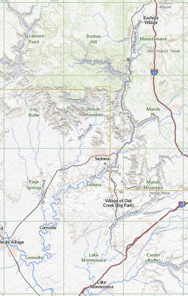
Sedona Index Map