Tucson and Surrounding Area
While Saguaro National Park is the crown jewel of the Tucson area there are many other great locations.
- If you enjoy shooting architecture you should visit Mission San Xavier del Bac or the Tumacacori Mission. Get there early as both missions can get very crowded. The interior of Mission San Xavier del Bac opens to the public at 7:00 AM and is spectacular, as is the outside which can be shot at any time. The mission seems to be in a state of continual repair and you'll need to choose your shots accordingly. The best side of the mission faces south. It photographs well at night (star trails to the north), during the blue hour, and at sunrise. For the interior a wide angle lens works best, I shot at 12mm and would have liked to be able to go wider. Tripods appear to be allowed inside the church.
- If you enjoy viewing the works of the masters you should visit the Center for Creative Photography, founded in 1975 by Ansel Adams.
- If shooting windows and doors is a favorite pastime, visit Barrio Viejo. S Meyer Ave between 17th Street and 19th Street is a good place to start, and parking is freely available.
- The Cox Butterfly and Orchid Pavilion at the Tucson Botanical Gardens features tropical butterflies from around the world.
- In 2017 the Arizona-Senora Desert Museum was rated the number three zoo in the US by the readers of USA Today, ahead of many notables including the renowned San Diego Zoo. You should definitely visit the Bighorn Sheep, the mountain woodland (for mountain lions), the Hummingbird Aviary, the Raptor free flight, and the cactus garden.
- In addition to Saguaro NP there are many other great locations for landscape photographers. These include Sabino and Bear Canyons, Gates Pass, and Windy Point on Mount Lemmon. Parking at Windy Point is limited so get there well before sunset.
Google Map of the Tucson Area
Here is a Google map showing the locations of the above as well as most of the many trails in Saguaro National Park:
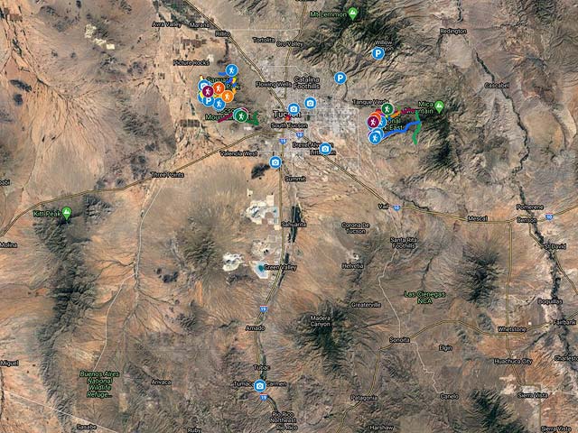
To view the map in Google Maps please click anywhere on the map above.
- Click to download a KMZ file (Note - in IE Right Click and choose Save Target as)
- Click to download a KML file (Note - KML files do not include custom icons)
- Click to download a GPX file (Note - in IE Right Click and choose Save Target as)
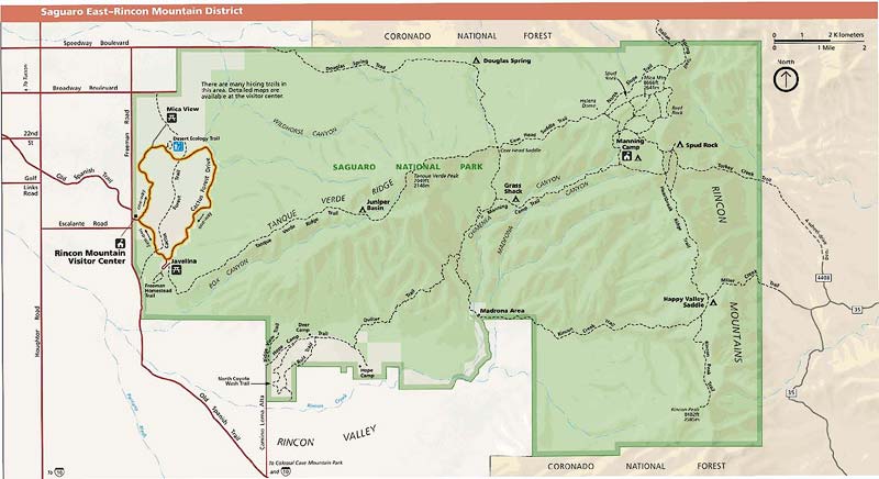
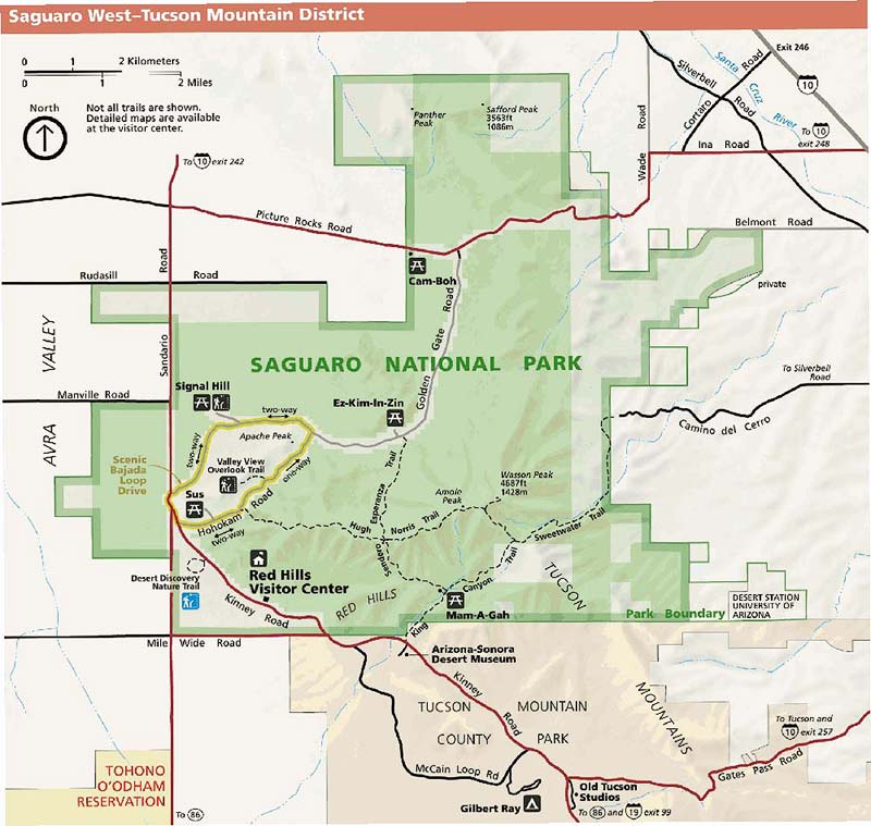
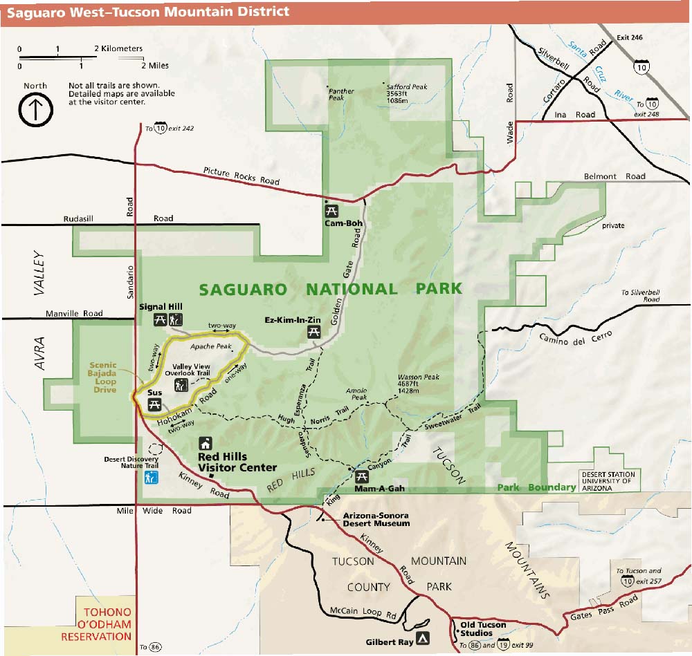
Saguaro National Park
Saguaro National Park is comprised of two districts, an east district and a west district, separated by the City of Tucson. It takes about 45 minutes to drive from one district to the other, so plan your trip accordingly. Below are the official Saguaro National Park maps for both districts as jpegs and in three geocoded formats, as GeoTiffs, as KMZ files, and in Oruxmaps format. The official park map as a PDF for the east district can be found here, and the map for the west district here . The jpeg image below displays in low resolution, however if you download it you will get a full resolution 300dpi image. To download the full resolution jpeg right click on the image and choose Save Image As.
- Click to download a high resolution Jpeg file. File is not geocoded.
- Click to download a GeoTiff file viewable in PDF Maps
- Click to download a KMZ file viewable in Google Earth
- Click to download an Oruxmap file (Note - in IE Right Click and choose Save Target as)
Saguaro National Park Trails
The tables below contain KML and GPX routes for 50 hikes. The hikes have been divided into two groups, those in the Saguaro NP East and those in Saguaro NP West. Many of the trails are out and back but often several trails can be combined to produce a loop. Alternatively if two vehicles are available some great one way hikes can be constructed by combining several trails. Hiking distances shown below are one-way for out and back trails and total round-trip for loop trails. To use the information below first select a hike using a different source such as a book on Tucson hikes and find the corresponding trail (or trails) below. Download either a KML or GPX file to your GPS or phone. You can then follow the trail on your GPS / phone as you hike. You can also download a KML file to your PC or MAC and view it in Google Earth. In Google Earth 3D views are available, and you can see an elevation profile by right clicking on a trail.
| Trail | Miles | Download a KML | Download a GPX |
| Bajada Wash Trail | 1.6 | KML | GPX |
| Brittlebrush Trail | 1.3 | KML | GPX |
| Cactus Canyon Trail | 1.8 | KML | GPX |
| Cactus Wren Trail | 2.0 | KML | GPX |
| Cam-Boh Trail | 2.5 | KML | GPX |
| Cheops Trail | 0.3 | KML | GPX |
| Coyote Pass Trail | 0.85 | KML | GPX |
| Desert Discovery Nature Trail | 0.4 | KML | GPX |
| Dobe Wash Trail | 1.4 | KML | GPX |
| Encinas Trail | 3.0 | KML | GPX |
| Gates Pass Trail | 4.4 | KML | GPX |
| Gould Mine Trail | 1.1 | KML | GPX |
| Hugh Norris Trail | 4.6 | KML | GPX |
| Ironwood Forest Trail | 1.4 | KML | GPX |
| King Canyon Trail | 2.3 | KML | GPX |
| Manville Trai | 2.4 | KML | GPX |
| Picture Wash Rocks Trail | 2.2 | KML | GPX |
| Rattlesnake Trail | 0.1 | KML | GPX |
| Ringtail Trail | 0.95 | KML | GPX |
| Sendero Esperanza Trail | 3.2 | KML | GPX |
| Sweetwater Trail | 4.7 | KML | GPX |
| Thunderbird Trail | 0.8 | KML | GPX |
| Valley View Overlook Trail | 0.4 | KML | GPX |
| Wild Dog Trail | 1.0 | KML | GPX |
| Yetman Trail | 6.1 | KML | GPX |
| All Saguaro NP West | KML | GPX |
| Trail | Miles | Download a KML | Download a GPX |
| Arizona Trail | 8.5 | KML | GPX |
| Bajada Vista Trail | 0.65 | KML | GPX |
| Bridal Wreath Falls Trail | 0.35 | KML | GPX |
| Cactus Forest Trail South | 2.5 | KML | GPX |
| Cactus Forest Trail | 1.8 | KML | GPX |
| Carillo Trail | 3.8 | KML | GPX |
| Cholla Trail | 0.7 | KML | GPX |
| Deer Valley Trail | 0.4 | KML | GPX |
| Desert Ecology Trail | 0.3 | KML | GPX |
| Douglas Springs Trail | 6.2 | KML | GPX |
| Ernies Falls Trail | 1.1 | KML | GPX |
| Freeman Homestead Trail | 0.9 | KML | GPX |
| Garwood Trail | 0.6 | KML | GPX |
| Kennedy Trail | 0.4 | KML | GPX |
| Loma Verde Trail | 2.4 | KML | GPX |
| Mesquite Trail | 1.0 | KML | GPX |
| Mica View Trail | 0.7 | KML | GPX |
| Pink Hill Trail | 1.6 | KML | GPX |
| Shantz Trail | 4.9 | KML | GPX |
| Squeeze Pen Trail | 0.5 | KML | GPX |
| Tanque Verde Ridge Trail | 11.1 | KML | GPX |
| Three Tank Trail | 2.2 | KML | GPX |
| Vanover Trail | 1.6 | KML | GPX |
| Wild Horse Canyon Trail | 1.5 | KML | GPX |
| Wildhorse Trail | 0.7 | KML | GPX |
| All Saguaro NP East | KML | GPX |