The Recapture Pocket
The Recapture Pocket is a rarely photographed area of badlands near Bluff, Utah. Like Goblin Valley, it is filled with hoodoos of all shapes and sizes. It is comprised of three distinct areas, the first two are quite close, and the third is about 1.5 miles away. The Recapture Pocket is only a fifteen minute detour from Highway 191 in Bluff, so if you are travelling between Moab and Monument Valley or in the Cedar Mesa area consider stopping off on your way. You'll probably have Recapture Pocket to yourself, and there are many good photos to be had. Recapture Pocket is best shot at dawn as there are colorful hills to the west which will partially block the light at sunset.
Getting There
To get to the first two groupings proceed as follows. From the intersection of US 191 and Utah 162 go east on 162 3.5 miles to Utah 163 and turn left. Continue 0.5 miles and bear right onto a dirt road at the Y. Continue .6 miles and bear right at the Y onto Cow Canyon Road (County Road 217). After 1.1 miles turn left onto Bluff Bench Road. Continue of Bluff Bench Road for 0.8 miles and turn left. This road is pretty rough, you will need a high clearancew 4x4 to drive it; alternatively you can walk. After .25 miles you'll see the first group of hoodoos on your right, park anywhere. After visiting the first group continue west on the same road for an additional .3 miles to the second group. The second group is the most photogenic as it is partially surrounded by colorful cliffs to the west. I only briefly visited the third group of hoodoos as the light was gone by the time I got to them. The route to the third group is shown on the map below and is in poor condition. In good conditions a private passenger is sufficient for all but the last leg on the route.
If you are visiting Recapture Pocket at dawn I suggest you go to the first group of hoodoos before the second group. The first group will get light a bit earlier than the second. If you are going at sunset I suggest you arrive a few hours before dusk and shoot the second group first before they go into shadow.
Google map of The Recapture Pocket
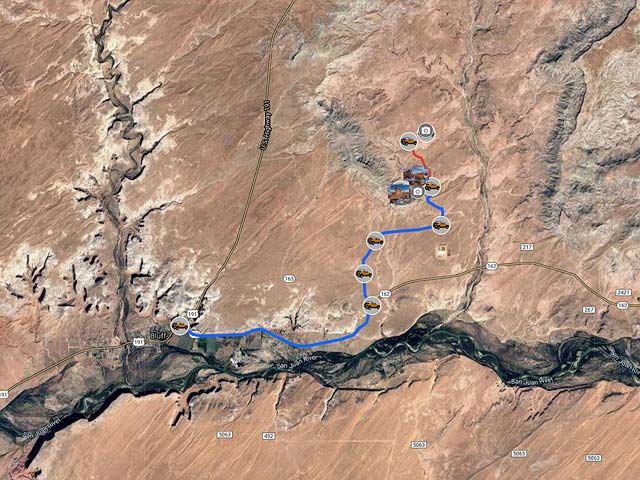
To view the map in Google Maps please click anywhere on the map above.
- Click to download a KMZ file (Note - in IE Right Click and choose Save Target as).
- Click to download a KML file (Note - KML Files do not include custom icons).
- Click to download a GPX file (Note - in IE Right Click and choose Save Target as).
USGS 24K Topo Maps
Recapture Pocket is covered by the Recapture Pocket USGS 24K map. This map can be downloaded in a variety of formats below:
| Geo Tiff/Avenza | KMZ | Oruxmaps | KMZ Decollared | Oruxmap Decollared | Avenza Decollared |
| Recapture Pocket | KMZ | Oruxmap | KMZ Decollared | Oruxmap Decollared | Avenza Decollared |