The Paria Movie Set
The Paria Movie Set is an area of beautifully colored bentonite hills. It was the site of an old movie set and the Pahreah ghost town. It is accessed from a clay based six mile long road that runs from Highway 89 to the Paria River. When dry this road is in good condition for the first 4.8 miles after which it deteriorates quickly. A 4x4 is needed to access the areas past 4.8 miles. When the road is wet it is a sea of mud and is impassable and dangerous to all vehicles. Movies were filmed at the Paria Movie Set from the 1930's through 1976. In 1976 the Clint Eastwood movie "The Outlaw Josey Wales" was shot there. The movie set was damaged by flooding in 1998 and was rebuilt by volunteers. In 1996 the Paria Movie Set burned down as the result of a suspicious fire. It has not been rebuilt.
The old Pahreah ghost town is about one mile from the parking area and is on the other side of the Paria River. It was occupied from 1865 until 1929. To visit what's left of the few remaining Pahreah buildings you must wade across the Paria River. Driving in or across the river is strictly prohibited. There is a graveyard with about twenty graves in the area as well.
To get to the Paria Movie Set taken US 89 from either Page or Kanab to milepost 30.7 and turn north. Drive 4.7 miles to the large parking area next to the campground. The campground has three sites with tables, grills, and pit toilets, but no water. If you have a high clearance 4 wheel drive vehicle you can drive down to the Paria River and can also visit the old Pahreah cemetery. The textures in the chinle show up best in the afternoon when some shadows are present. Good overview pictures can even be made mid-day since images here are all about color. If you shoot mid-day some clouds will add contrast and really enhance your pictures.
The House Rock Clay Beds
If you take House Rock Road to Wirepass Trailhead from the south you will notice an area of beautifully striped chinle to the right (east). This area is known as the House Rock Clay Beds. The Clay Beds area consists of two distinct groupings of chinle separated by a ridge. I'll call them Clay Beds North and Clay Beds South. Clay Beds North is the better of the two.
To access the Clay Beds from the north take House Rock Valley Road (HRVR) for 12 miles and turn left just before a steep hill. From the south take HRVR 17.6 miles and turn sharp right just after descending the hill. Park in the small circle 150 yards down the road. You can dry camp there. To hike to the Clay Beds North from the parking area follow the wash that runs east until you reach the barbed wire fence. Find a way under or over the fence and explore the area to your heart's content. To get to Clay Beds South after visiting Clay Beds North you need to cross the ridge between the two. There are good pictures to be had from this ridge. Alternatively to get to Clay Beds South from the parking area hike down the wash running south for about 0.5 miles. When you reach 36.96298, -112.03177 you'll see a wash coming in from the left, follow it to the clay beds.
The clay beds are best photographed late in the day. Do not visit the area after a rain as I once did. When wet the Chinle is like quicksand and you will get stuck. On a recent hike there in the winter about one week after a rain my feet got stuck in the chinle and it took me almost 25 minutes! to extricate myself.
Map of the Paria Movie Set and Clay Beds
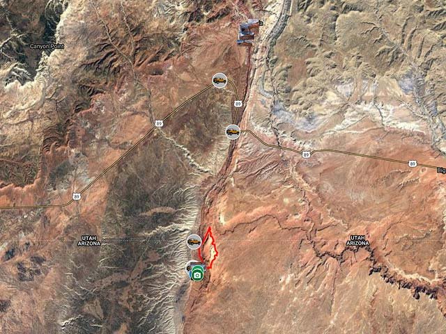
To view the map in Google Maps please click anywhere on the map above.
- Click to download a KMZ file (Note - in IE Right Click and choose Save Target as)
- Click to download a KML file (Note - in IE Right Click and choose Save Target as)
- Click to download a GPX file (Note - in IE Right Click and choose Save Target as)
USGS 24K Topo Maps
The Paria Movie Set area is covered by the USGS 24K Five Mile Valley map.
| Geo Tiff/Avenza | KMZ | Oruxmaps | KMZ Decollared | Oruxmap Decollared | Avenza Decollared |
| Five Mile Valley | KMZ | Oruxmap | KMZ Decollared | Oruxmap Decollared | Avenza Decollared |
The House Rock Clay Beds area is covered by the USGS 24K Coyote Buttes map.
| Geo Tiff/Avenza | KMZ | Oruxmaps | KMZ Decollared | Oruxmap Decollared | Avenza Decollared |
| Coyote Buttes | KMZ | Oruxmap | KMZ Decollared | Oruxmap Decollared | Avenza Decollared |