Northern California
Northern California is a land of spectacular coastal beaches, redwood forests, active volcanoes, mountain lakes, the most beautiful waterfalls in the state, and wineries!
Waterfalls
The waterfalls in northern California are concentrated in the Mount Shasta area. Three of them are near Mt Shasta City:
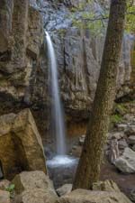
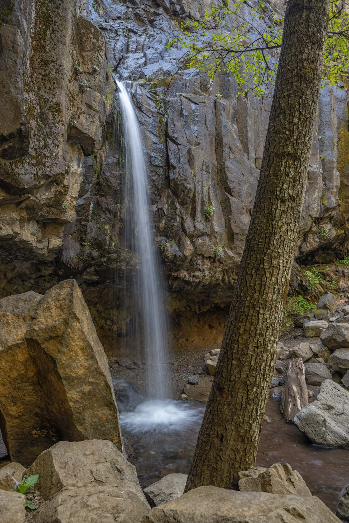
Hedge Creek Falls
Hedge Creek Falls is the easiest of the three falls to access. It is located near the town of Dunsmuir, California. There is an alcove behind the falls, and you can walk behind the waterfall without getting wet. You can view the cascade from behind it. The best views of the waterfall are from its north side where trees and rocks nicely frame it. You can easily remove the extensive graffiti on the nearby rocks in post. The waterfall is fed by a seasonal creek with the best flows from December through May. Snow may make the short trail to the falls treacherous in the winter. I suggest you visit the falls from March through early May or just after a rainfall. You can find climate for the nearby town of Dunsmuir at usclimatedata.com.
The trail to Hedge Creek Falls begins at the intersection of Dunsmuir Avenue and Siskiyou Avenue in Dunsmuir. The hike is only .17 miles long with 180 feet elevation drop. The trail passes under the falls and continues downstream along Hedge Creek to the Sacramento River. It is possible to cross the Sacramento River here, and this is one way to access Mossbrae Falls. The Sacramento can be quite deep and dangerous when the flow is moderate to high, so I only recommend it if you are experienced in river crossings and go with others.
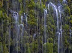
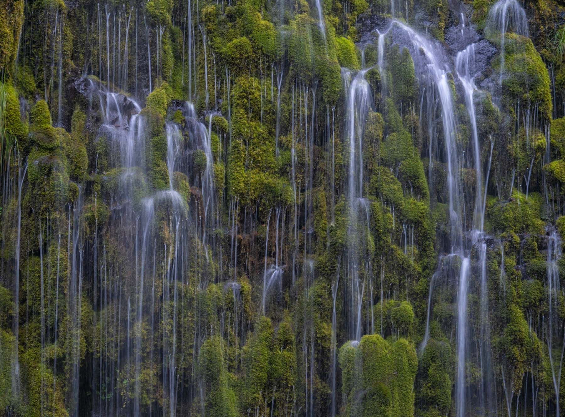
Mossbrae Falls
Mossbrae Falls is only .3 miles from Hedge Creek Falls as the crow flies, but, as the saying goes, "you ain't no crow". The falls is one of the most striking in northern California. Unfortunately, the trail to Mossbrae Falls is now closed. The trail crosses Union Pacific property. This part of the trail is closed due to a fatality some years ago when a hiker was hit by a train. If you take this trail, you may face a fine for trespassing on Union Pacific property.
Here are directions to the falls if you decide to do the hike anyway, as I did:
- Park in Dunsmuir on Dunsmuir Avenue. Parking near the old trailhead at Scarlet Way is now illegal. You will need to park on Dunsmuir Avenue north of Isgrigg St. Parking is legal there.
- Walk south on Dunsmuir a few blocks to Scarlet Way.
- Scarlet Way is a private road in a retreat. I understand that the retreat does not mind people walking on this road. Be respectful and keep a low profile while in the retreat. Do not drive your car onto the retreat's property. Follow Scarlet Way till it becomes Cave Avenue and continue on Cave until it crosses the Sacramento River.
- Cross the Sacramento River and turn right at the train tracks. Do not walk on the tracks. Walk on the gravel on the river (right) side of the tracks for 1.15 miles. You will come to another bridge over the Sacramento River. A train of nearly 100 cars passed us on the way to the falls. We heard the train when it was 200 yards away and waited for it to pass by. A typical freight train is over a mile long and requires over a mile to stop after applying its emergency brakes. Listen carefully for trains and stay off the tracks.
- Just before the bridge over the Sacramento River, turn right onto a social trail and follow it to the nearby falls.
An official and safe trail to Mossbrae Falls is currently in planning and Union Pacific has accepted engineering plans. The trail will begin at the Hedge Creek Falls trailhead. The date for the trail opening has yet to be set.
Mossbrae Falls is spring fed and runs all year. The falls are only 50 feet high but are several hundred feet wide. The falls face west and get light in mid to late afternoon. I was there on a cloudy day and got good pictures while the falls were in the shade. Bring a moderate telephoto and focus on some of the details in the falls.
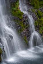
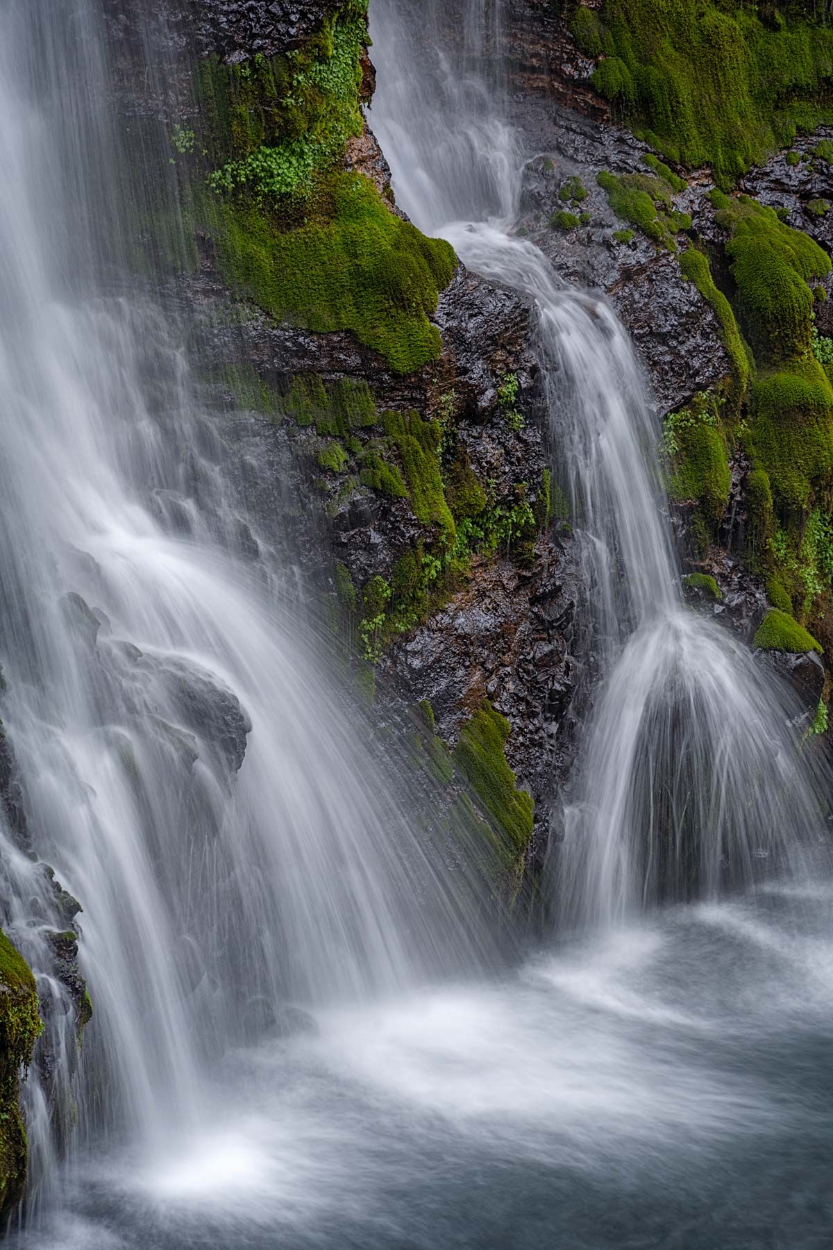
Burney Falls
Burney Falls is perhaps the most beautiful waterfall in the state of California. It is about an hour southeast of Dunsmuir. It is spring fed with a flow of nearly 100 million gallons per day year-round. The water temperature at the base of Burney is a constant 42°F. The creek below the falls is very popular with fly fishermen going for rainbow and other trout. Information about fishing in the park can be found at the Times-Standard.
Burney Falls is in the McArthur-Burney Falls Memorial State Park. To access the falls, park in either of the first two lots you come to after the fee station and take the Rainbow Loop trail .15 miles and 150 feet down to several good viewpoints of the base of the falls. The full loop trail is 1 mile long, but the best photography is at the base. The falls face northeast and get good light in the morning once the sun has risen over the ridge to its east. A mid-telephoto (70-200mm) lens works well to capture the details in the falls.
McArthur Burney Falls State Park is quite popular and fills to capacity on holidays and all weekends in the summer. I suggest you go early in the morning. Admission to the park is $10 per vehicle. Overnight camping is available by reservation, $35 per night, no hookups. Showers and a dumpstation are available. Vehicles over 32 feet long cannot be accommodated.
Northern California Coast
Point Arena Lighthouse
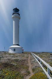
At 115 feet high, this is the tallest lighthouse on the west coast. The 270° view of the ocean from the lantern room at the top is spectacular; you'll need an ultrawide or panorama rig to capture it. Tower tours are available from 10:15 am to 4:00 pm and run roughly every twenty minutes. The cost is $5 per person. Masks required.
If you wish to photograph the lighthouse from terra firma, the lighthouse grounds ("Point Arena Museum") are open from 10:15 am to 4 pm, and the cost is $5 per car. The limited hours make photographing the lighthouse at sunset difficult. To shoot the lighthouse at sunset, you can either register for a "Full Moon Tour," or you can stay overnight at one of the Point Arena guest cottages. Full Moon tours are held monthly on the Saturday closest to the full moon. Tours are held near sunset, the cost is $50 per person, and reservations are required. At sunset the full moon rises to the east, making it impossible to capture an image of a large full moon over the lighthouse. You must book an overnight stay at a guest cottage if you want to shoot the classic full moon over lighthouse image.
Other things to shoot in the area include the Point Arena arches and the sea lions on the Sea Lion Rocks. The rocks are offshore just south of the lighthouse. Shoot from the promontories off the Point Arena Stornetta Coastal Trail. You will need a long lens to photograph or video the sea lions.
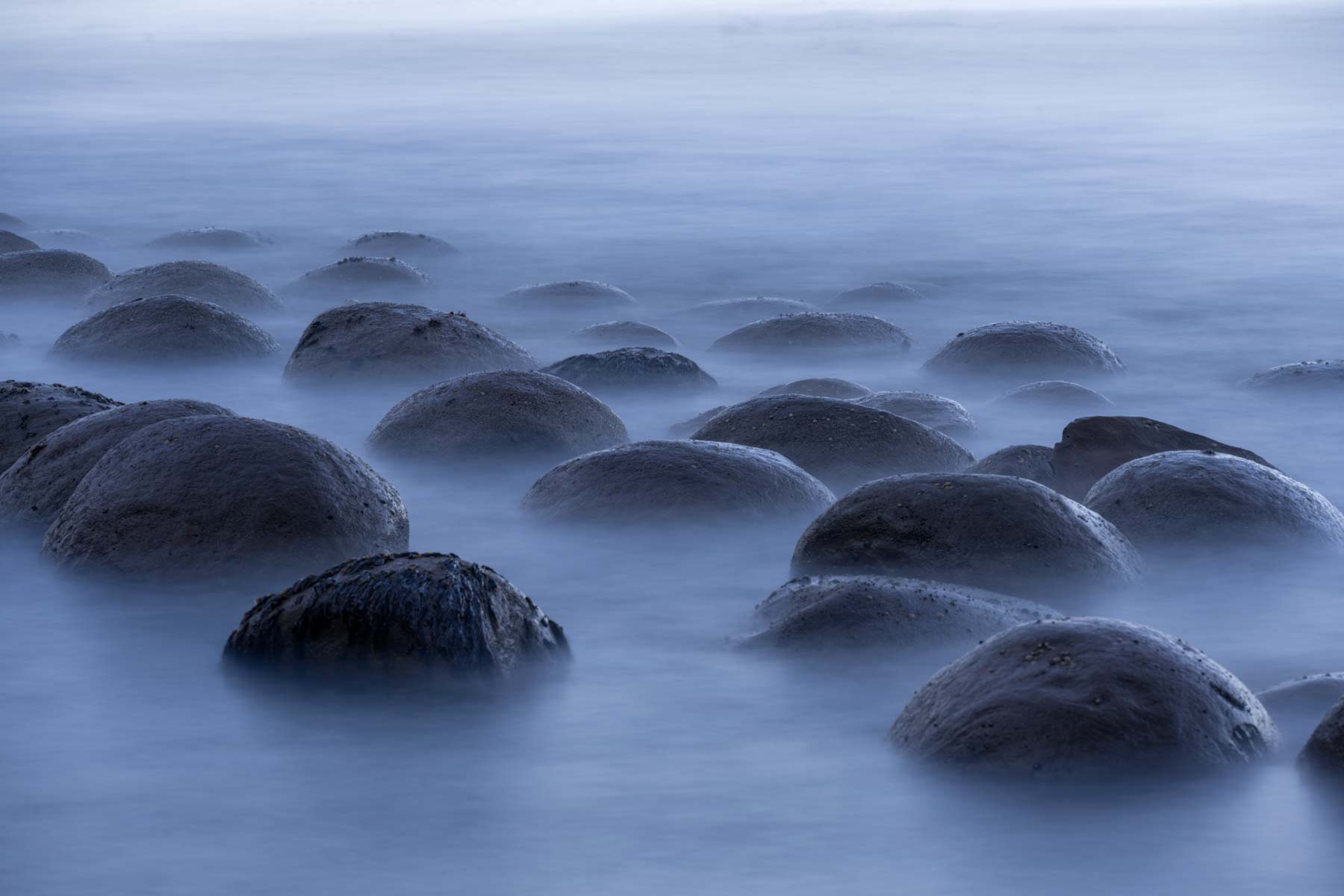
Bowling Ball Beach
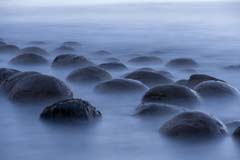
Just north of Schooner Gulch there is a collection of round rocks that resemble bowling balls lying on the beach. At very low tide the rocks are largely exposed, and at high tide the rocks are submerged. During these times photography is uninteresting. When tides are one or two feet above sea level, the rocks are partly submerged and have an ethereal appearance when shot using a long exposure (30 seconds or more). The rocks are the best when shot at sunset. Night photography works well here as well. I suggest shooting later in the season (August through October) when the Milky Way is to the southwest and is more vertical. You'll want to consult the Mendocino Bay tide table before planning a trip to Bowling Ball Beach. Alternatively, the Tides 6.0 app by David Easton is an excellent app for Android and contains tide tables worldwide. You can get it at the Google Play store. The cost is $1.99. For Apple Tide-charts is well reviewed though I have not had a chance to use it.
While in the area shoot the small but photogenic coastal arch 100 yards north of Schooner Gulch. I've named it Schooner Gulch arch. You will need to shoot from the arches north side.
Salt Point State Park
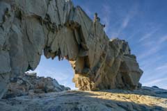
The weathered sandstone in Salt Point State Park is reminiscent of that in southern Utah. The sandstone at the park forms spectacular gray and orange pinnacles and hoodoos. These contrast beautifully with the blues of the Pacific ocean. The rocks are also pitted with small holes known as tafoni. The best feature is Keystone Arch, seen above. The arch is in a depression, so the best light occurs a few hours after sunrise or before sunset. Access may be difficult at high tide.
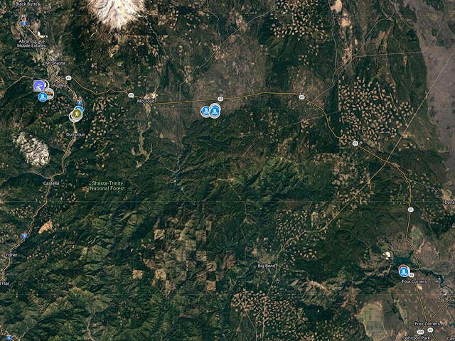
Google Map of Northern California
Here is an overview map showing the locations of many of the waterfalls and other attractions in northern California. Click on the map to open a larger version of the map in a new window.
- Click to download a KMZ file (Note - in IE Right Click and choose Save Target as)
- Click to download a KML file (Note - KML files do not include custom icons)
- Click to download a GPX file (Note - in IE Right Click and choose Save Target as)
USGS 24K Topo Maps
The following four maps cover Burney Falls, the Lake McCloud waterfalls, and Faery, Mossbrae, and Hedge Creek Falls in the Dunsmuir area. The merged map includes the City of Mt Shasta and Dunsmuir maps only.