Iceland
Road Conditions and Alerts
A map showing winter road conditions in Iceland can be found at http://www.road.is/travel-info/road-conditions-and-weather/entire-iceland-road-conditions-map/.
Alerts about road conditions and weather can be found at: https://safetravel.is . You can even leave your travel plans with them so that Iceland Search and Rescue has some idea where to begin a search should trouble arise.
Weather and Climate
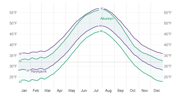
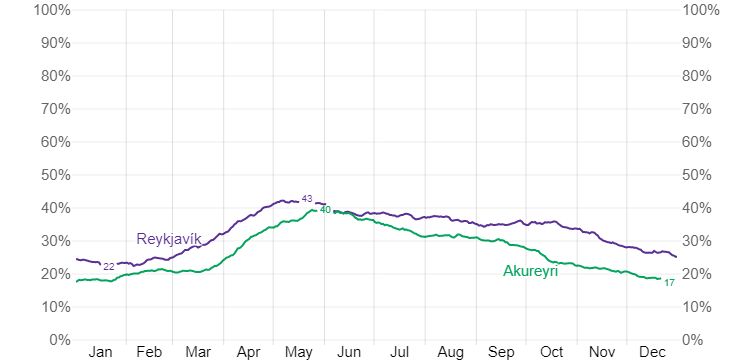
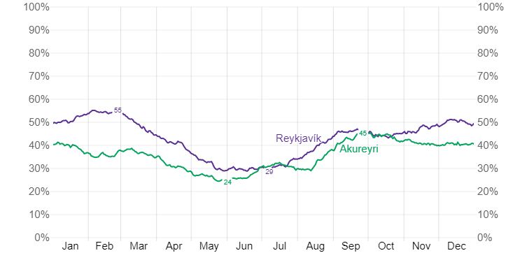
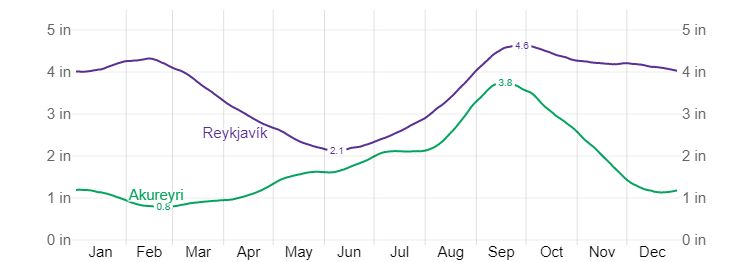
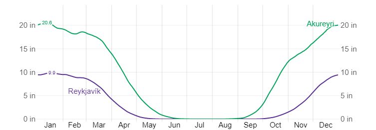
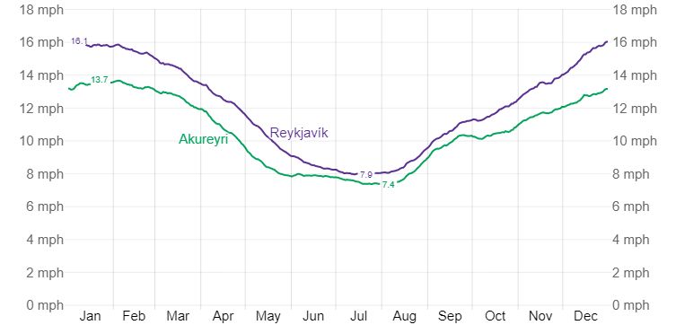
The following graphs are from weatherspark.com. Based on these graphs early June would be a good time to visit Iceland as you have the best chance of a clear sky, relatively low average rainfall, low winds, and little chance of snow. Even in June the daily chance of a clear to partly cloudy sky is only 40%. On June 21st Akureyri in northern Iceland gets 23.6 hours of daylight!
Five day weather forecasts for all of Iceland can be found at: http://en.vedur.is/weather/forecasts/areas/#view=map and a table showing hourly forecasts for specific locations can be found at: http://en.vedur.is/weather/forecasts/areas/#view=table .
Google Map of Iceland
Below is an overview map showing many areas of photographic interest.

To view the map in Google Maps please click anywhere on the map above.
- Click to download a KMZ file (Note - in IE Right Click and choose Save Target as)
- Click to download a KML file (Note - KML files do not include custom icons)
- Click to download a GPX file (Note - in IE Right Click and choose Save Target as)
Iceland 100K Topo Maps
Decollared topo maps are freely available for Iceland from the National Land Survey of Iceland. After you enter your name and email on the Iceland site you will get a link to the maps. Raster maps are available at the 50K, 100K, and 250K resolutions. The 50K maps are in Black and White so I choose to download 100K maps. The 100K maps use the EPSG3057 Iceland ISN93 grid. The maps can be converted to other formats using MAPC2MAPC. The current version (June 2017) of MAPC2MAPC does not directly support this grid so you need to add it manually. To do this proceed as follows:
- In the Oruxmaps program folder there is a file "m2grids.txt"
- Use an editor like Notepad to add this line to it
- EPSG3057 Iceland ISN93,WGS 84,2,65,-19,500000,500000,1,0,7,7,64.25,65.75
- Depending on your system you may need to save it elsewhere then copy back to the program folder.
- Then open the TIF or TFW and on the TFW Parameters panel, and scroll down to select EPSG3057
Iceland is covered by 91 topo maps, with KORT 2 being the NW corner, and KORT 115 the SE. Kort means Map in Icelandic. Map numbers increase down and then across, e.g. KORT58 is below (south) of KORT57.
The maps can be downloaded in a variety of formats by clicking or right clicking below:
