Grand Falls
Grand Falls is one of the five highest waterfalls in Arizona. At 185 feet high it is taller than Niagara Falls (183 feet) though not nearly as wide (est. 200 feet). Grand Falls is part of the Little Colorado River and its headwaters are in the White Mountains in eastern Arizona and western New Mexico. Most of the year the Little Colorado River does not flow so you need to plan ahead or be lucky to see the falls when running. Grand Falls is so muddy it is also known as Chocolate Falls or Muddy Falls. Note that a Navajo Nation permit is needed to visit Grand Falls. Information on permits is available here.
When to Go
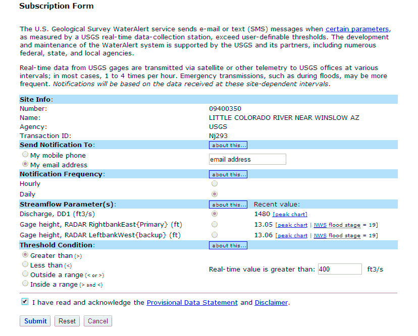
Most of the year Grand Falls does not flow. It is so dry Navajo Route 70 crosses the Little Colorado riverbed just above the falls, as do several other crossings. That said, Grand Falls typically does flow 7-8 times a year. It flows for two reasons: snowmelt in the White Mountains in March and April, and a few days after a heavy rainfall. Your best chance of seeing the falls flowing is to go a few days after a heavy rainstorm in eastern Arizona. There is a USGS water height and flow gauge for the Little Colorado at Winslow, Arizona. Winslow is upstream of the Grand Falls. If there is a good flow at Winslow there will be a good flow at the Grand Falls a few days later. It takes about two days for a heavy flow recorded in Winslow to make its way downstream to Grand Falls. Streamflow at Winslow can be monitored at this link. You can even sign up to have an email or text alert sent to you when stream flow at Winslow exceeds a certain amount. You can sign up at this link. Here is how I setup my alert:
If you are planning a trip to the southwest weeks or month in advance tracking flow at Winslow is not an option. In this case I suggest you plan your trip for late March or early April which historically has been the period when snowmelt is its maximum.
The next section contains a statistical analysis of the Little Colrado river flow. It can be skipped unless you are really interested in the data underlying the above recommendation.
Analysis
River flow data is not available at Grand Falls itself, however data from USGS flow stations is available for nearby towns Winslow and Cameron. Winslow is roughly 75 river miles upstream from Grand Falls, and Cameron is forty miles downstream. Using the Cameron data (closest USGS station to Grand Falls) as a proxy for Grand Falls data there is about a thirteen percent chance that the Grand Falls flow will exceed 400 cubic feet per second (cfs) on any given day in the year. The value 400 cfs was selected assuming a good flow happens when water two feet high flows down the 200 foot wide Little Colorado river each second.
The following histogram shows the probabilities of various flows at the Cameron USGS gauge station:
| CFS | Probability of Flow |
| <10 | 58.80% |
| 10-25 | 5.70% |
| 25-50 | 5.60% |
| 50-100 | 6.10% |
| 100-250 | 7.30% |
| 250-400 | 3.60% |
| 400-1000 | 6.80% |
| >1000 | 6.10% |
From the chart there is a 75 percent chance flow is negligible or low (<100 cfs) , about a ten percent chance of moderate flow (100-400 cfs), and a thirteen percent chance of high flow (>400 cfs).
The daily USGS data can also be summarized by month, here are the probabilities of a flow and the number of consecutive days flow exceeds 400 cfs:
| Month | Probability of Flow | Period of Flow in Days |
| January | 9% | 6.4 |
| February | 15% | 7.6 |
| March | 33% | 9.9 |
| April | 33% | 24.3 |
| May | 6% | 21 |
| June | 0% | 2.7 |
| July | 8% | 2.9 |
| August | 22% | 4.3 |
| September | 14% | 3.2 |
| October | 8% | 4.2 |
| November | 3% | 3.4 |
| December | 4% | 3 |
| Average | 13% | 6.2 |
Flows vary greatly by month, there is very little chance of a good flow in May, June, November, and December. There is a 1/3 chance of a good flow during the snowmelt season of March and April, and once a strong flow occurs it tends to last for a long time in those months.
In a typical year there are usually seven-eight flows with an average length (consecutive days flowing) of 6.2 days. Excluding data for March and April the average number of consecutive days of a flow is 4.4.
Finally, I did an analysis relating flow data at Cameron to flow data in Winslow. Since Grand Falls is roughly 2/3 of the way from Winslow to Cameron via the river if we know how long it takes a surge in the flow to travel to Cameron from Winslow we can estimate the amount of time it would take to reach Grand Falls. I did a lagged regression of flow data at Cameron versus flow data in Winslow for flows up to a week prior. Winslow flows up to five days prior were significant predictors of flow in Cameron and had the right sign. There is a strong same day correlation between Winslow and Cameron flows, probably due to heavy local storms affecting both at the same time. Flows from the first prior day, while significant, are not nearly as strong as flow for periods two to five days prior. The highest correlation and coefficients occurred in days three and four, suggesting it takes about three days for a flow in Winslow to reach Cameron. Since Grand Falls is about 2/3 of the way between the two, I believe that visiting Grand Falls two days after a good flow in Winslow is likely to be productive.
A zipped worksheet containing the raw data and my analysis can be downloaded here:
![]()
Photography Tips
Grand Falls is best shot between mid afternoon and sunset. A neutral density filter is needed if you wish to blur the water, I suggest using a six stop filter (ND 1.8). I typically shoot waterfalls at a shutter speed of about 1/3 of a second but you should bracket the speeds. Reflections in the mist below the falls can be partially removed using a polarizer. I've shot Grand Falls with focal lengths varying from 24mm to 300mm, with many in the 70mm to 200mm range, and have even taken some panos when I wanted to go wider than 24mm.
Consider shooting the falls from the bottom. The bottom can be accessed by walking the rim downstream until the dirt road ends. You should see a faint hiking trail heading down from the rim. Continue on the trail walking NNW to 35.42896, -111.20438 and then turn SE to get to the bottom. The path can be slippery when wet, and the bottom will be muddy in places. When shooting from the bottom you should bring a rain jacket for your camera and boots.
Directions
In normal conditions a private passenger car is sufficient to get you to Grand Falls, except for the last half milewhich can be easily walked or driven if you have a 4x4.
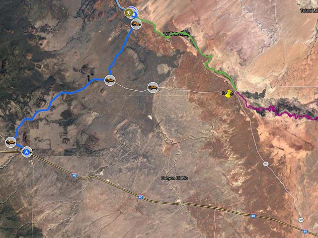
Here are directions from Flagstaff / I40:
- From Flagstaff take I40 east to exit 211 Winona
- At the end of the exit ramp turn left and head north .2 miles
- Turn left onto Townsend Winona Rd
- Continue 2.1 mi and turn right onto Leupp Rd Navajo Route 15. I have seen seversal speeding tickets given in this two mile stretch.
- Continue 19.9 mi on NR15 and turn left onto Navajo Route 6910
- Continue on Navajo Route 6910 7.9 mi
- Merge onto Navajo Route 70
- Continue on Navajo Route 70 1.1 miles, and turn left
- Walk or drive the muddy roads following the map below till you reach the overlook
The map below also shows directions from SR 89 for those coming from the north, and also shows a slightly shorter route taking Navajo Route 70 Grand Falls Road instead of Navajo Route 6910. 6910 is the better of the two roads and I suggest you use this road rather than 70.
Google Map of Grand Falls Map
The map below contains three different routes To Grand Falls and shows the route to the bottom of the falls. By default only the layer showing the route from US40 and NR 6910 is turned on, if you are coming from the north or wish to take NR70 instead of NR6910 you can turn on the appropriate layers. Layers can be turned on or off via the check boxes next to the layers name.
Note that the new Google maps engine does not show you latitude/longitude of points, elevation, or the distance between two points on the map. If you need these I suggest you download the KML file for the map and load it into Google Earth or another mapping tool.
To view the map in Google Maps please click anywhere on the map above.
- Click to download a KMZ file (Note - in IE Right Click and choose Save Target as)
- Click to download a KML file (Note - KML files do not include custom icons)
- Click to download a GPX file (Note - in IE Right Click and choose Save Target as)
USGS 24K Topo Maps
A map of Grand Falls can be downloaded in a variety of formats by clicking or right-clicking below:
| Geo Tiff/Avenza | KMZ | Oruxmaps | KMZ Decollared | Oruxmap Decollared | Avenza Decollared |
| Grand Falls | KMZ | Oruxmap | KMZ Decollared | Oruxmap Decollared | Avenza Decollared |