Current Weather
Page is the closest town to The Wave. There is a reporting weather station at the Page Airport (KPGA). Elevation at the Page weather station is 4,308 feet, about 900 feet lower than The Wave's. Temperatures at The Wave should run about 4°&F cooler than those in Page. The image to the right shows the current Page, Arizona weather and forecast in the "Weather" tab, wind direction and speed in the wind tab, and sunrise/sunset and moonrise/moonset times in the last two tabs.US National Weather Service provides the forecast.
Links to Other Weather Forecasts and History
Many websites provide 4- to 14-day forecasts at Page or The Wave. The forecasts are based on a variety of different weather models. Numerical weather prediction models, like the Global Forecast System (GFS) and European Centre for Medium-Range Weather Forecasts (ECMWF), divide the atmosphere into a grid system and use algorithms to calculate how variables such as temperature, humidity, wind speed, and pressure will evolve. Additionally, ensemble forecasting, employing multiple models that run with slight variations in initial conditions, helps estimate forecast uncertainty and improve reliability.
I recently started to use Windy.com, linked below, to check the weather forecast and snowpack. Windy provides hourly forecasts at any point on the earth. In North America it shows forecasts for six different models. The models are ECMWF, GFS, ICON, METEOBLUE, NAME, and HRRR. I typically use the ECMWF model. The ECMWF (European Centre for Medium-Range Weather Forecasts) model is widely considered the best for precipitation and cloudiness. ECMWF updates twice daily, usually around 5 AM Arizona time and 5 PM. When the weather looks dicey, I also use the comparison feature in Windy. Click the Compare button in the bottom middle on windy.com to compare the six forecasts.
- Forecast - Windy.com - The Wave
- Est. Snow Pack - Windy.com - The Wave
- Forecast - Weather Underground - Page, AZ
- Forecast - Accuweather - Page, AZ
- Forecast - National Weather Service Point Forecast - The Wave
- History - Weather Underground - Page, AZ
- Climate - Weatherspark.com
Snowpack
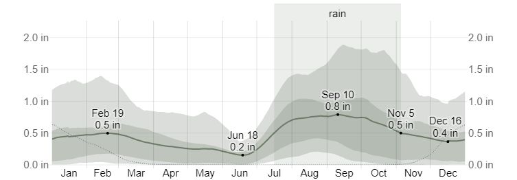
Snow occurs occasionally during the winter, with a few inches falling on average each month from mid-December to mid-March. If you plan to go in winter, check the snow depth first. You can find estimated snow depth at The Wave at Windy.Com. Windy.com provides snowpack information for locations worldwide. Both ECMWF and Icon projections are available. You can select the model via the box on the lower right on Windy.com. A color overlay shows estimated snow depth at map zoom levels of 11 and lower. The color legend appears at the lower right on windy.com. For zoom levels 12 and higher, right-click on the map and choose "Show Weather Picker." Grid spacing for the ECMWF is 9km as of 2023. Grid spacing for the Icon model is 13km. Conditions can vary greatly within a grid due to differing elevations, exposure to the sun, compaction, and drifting. Both models show projections for snow density. Densities of 100-200 are typical of fresh snow (powder), and 200-300 or more are typical for wet or compacted snow. Wet snow is generally harder to drive and walk on as it ices up.
Climate
A good source of climate information based on the Page airport data can be found at Weatherspark.com
When to Go
December to February
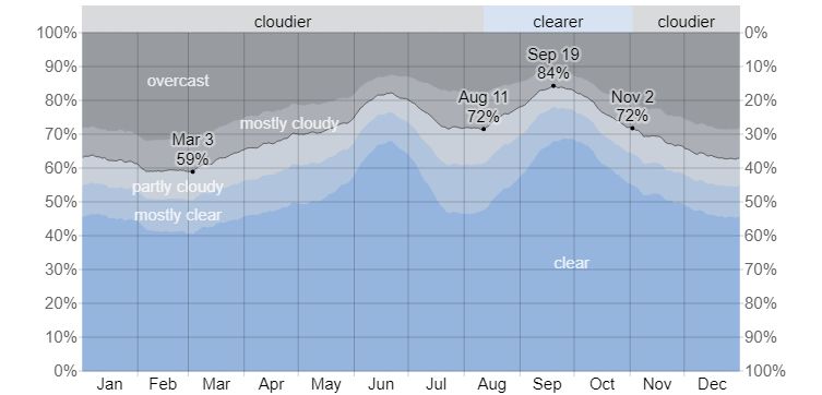
It is "relatively" easy to get permits in December, January, and early February, especially through the Daily lottery. Permits are hard to get around the Christmas and New Year holidays, so avoid these times. There is a good chance snow will be on the ground in winter. Snow makes hiking difficult and photographing the patterns in the red rock chancy. If there is snow, you may be limited to shooting southern exposures such as The Boneyard and Sand Cove. Average cloud cover is also high in winter, and House Rock Road is often muddy and difficult or impossible to drive on. When House Rock Road is muddy, consider hiring a guide to drive you to the trailhead. If you drive yourself when House Rock Road is wet, drive in existing ruts; if the road is dry, avoid the ruts. The South Buttes are even higher in elevation than the Wave, about 6,200 feet, or four degrees cooler. This makes snow even more likely in the South Buttes, and it will last longer. I have been to Cottonwood Cove when the north-facing exposures had over a foot of snow on them.
March - May
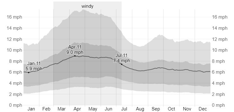
These are good months to visit, especially April and May when cloud cover is low and temperatures moderate. Getting a permit is very difficult. The average wind speed is highest in the southwest in the Spring. The wind comes from the Southwest in this area all year round, peaking in the afternoon. Sand Cove runs North-South and forms a natural wind tunnel. The high winds make good photography of Sand Cove and The Boneyard difficult in the Spring. Average cloud cover is low during May.
June
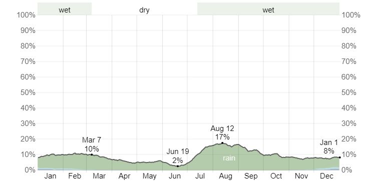
An excellent month to go to The Wave if you don't mind the heat. Cloud cover is low, as is precipitation. The best month for night photography as the Milky Way stretches across the sky.
July - August
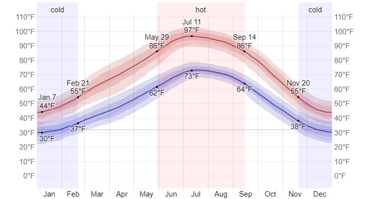
I used to believe these were the worst months to go to The Wave. I now believe they are reasonably good if you are prepared and can stand the heat. The average daily high temperature at the Wave is 101 ° F in July, and there is little shade. If you go in July, do not plan to be out all day. Either go in the morning when temperatures and cloud cover are lower or go in mid-afternoon if the weather looks cooperative. In 2013, there were three heat-related fatalities at the Wave, and there was another heat-related death in 2018. Every year there are several heat related rescue at The Wave. Go prepared. If you plan to stay the whole day, you must find shade. A space blanket can help; you must elevate it however you can (hiking sticks, rocks, bushes, etc.). A UV reflective umbrella can also help. A good place to find natural shade is on Toprock at the Alcove. Finally bring at least one gallon of water per person in July and August. You will need it. I have seen recommendations of nine liters per person per day when temperatures are this high! Keep water inside your pack so it stays cooler, and bring some of it as ice. If you freeze a water bottle, only fill it part way. Water expands by nine percent when freezing. There is a good possibility of afternoon thunderstorms or even hail. Mornings are cooler, often clear, and have little wind. You can likely get a good photograph in the morning, and if the weather cooperates, you may get a great one in the afternoon! With luck, there will be water at the Wave or in the water pockets south of The Wave. However, water pockets won't last long, given the average July-August temperatures. If there are water pockets, look for tadpoles and fairy shrimp. If there's a lot of water, you may even hear toads croaking! (males calling for females). Though still difficult, permits are easier to get than during peak months.
September - November
Excellent months for visiting. Page and Kanab are less crowded than during summer vacation, and cloud cover and temperatures are reasonable. Permits are very difficult to get. The rest of the Southwest is also beautiful at this time of year, with the Aspens changing in late September/early October and the Cottonwoods in late October.