The Eastern Sierras
The beauty of the countryside bordering California's Highway 395 rivals that of any other highway in the United States. Some of the more photogenic areas include, from south to north, the Trona Pinnacles, the Cerro Gordo ghost town, the Alabama Hills, the Ancient Bristlecone Pine Forest, Crowley Lake, and Mono Lake.
In addition to the above the mountains and lakes of the Eastern Sierras are also spectacular. This is particularly true in late September and early October when the aspen are changing color at the higher elevations. Exceptionally photogenic are Rock Creek, the Mammoth Lakes, Convict Lake, June Lake, Lundy Canyon, and areas north. The Mono County Economic Development, Tourism and Film Commission publishes a guide listing some of the best locations for fall color.
The Alabama Hills
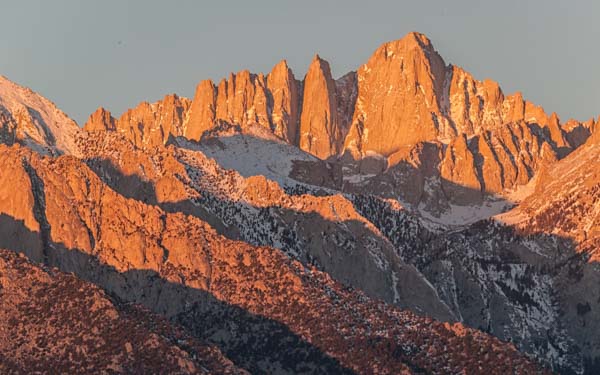
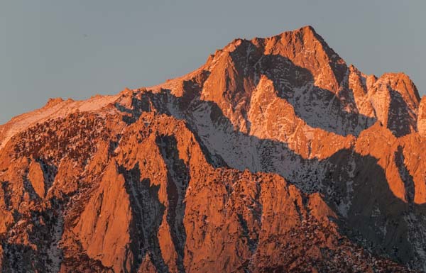
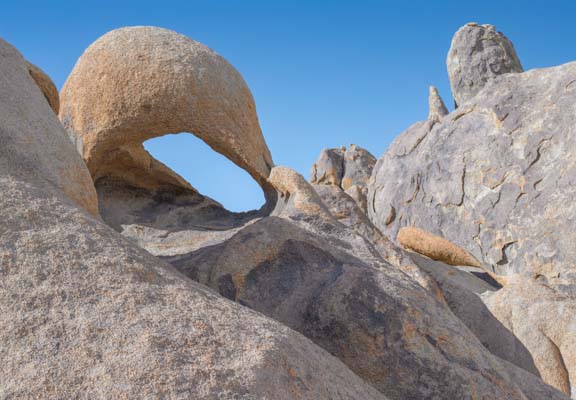
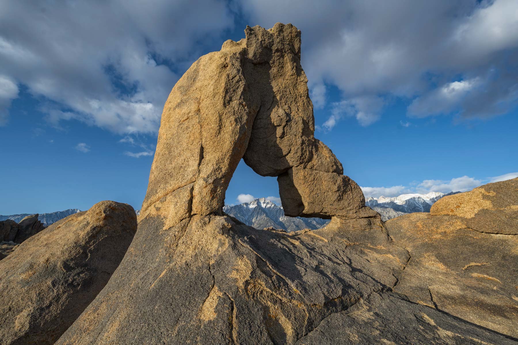
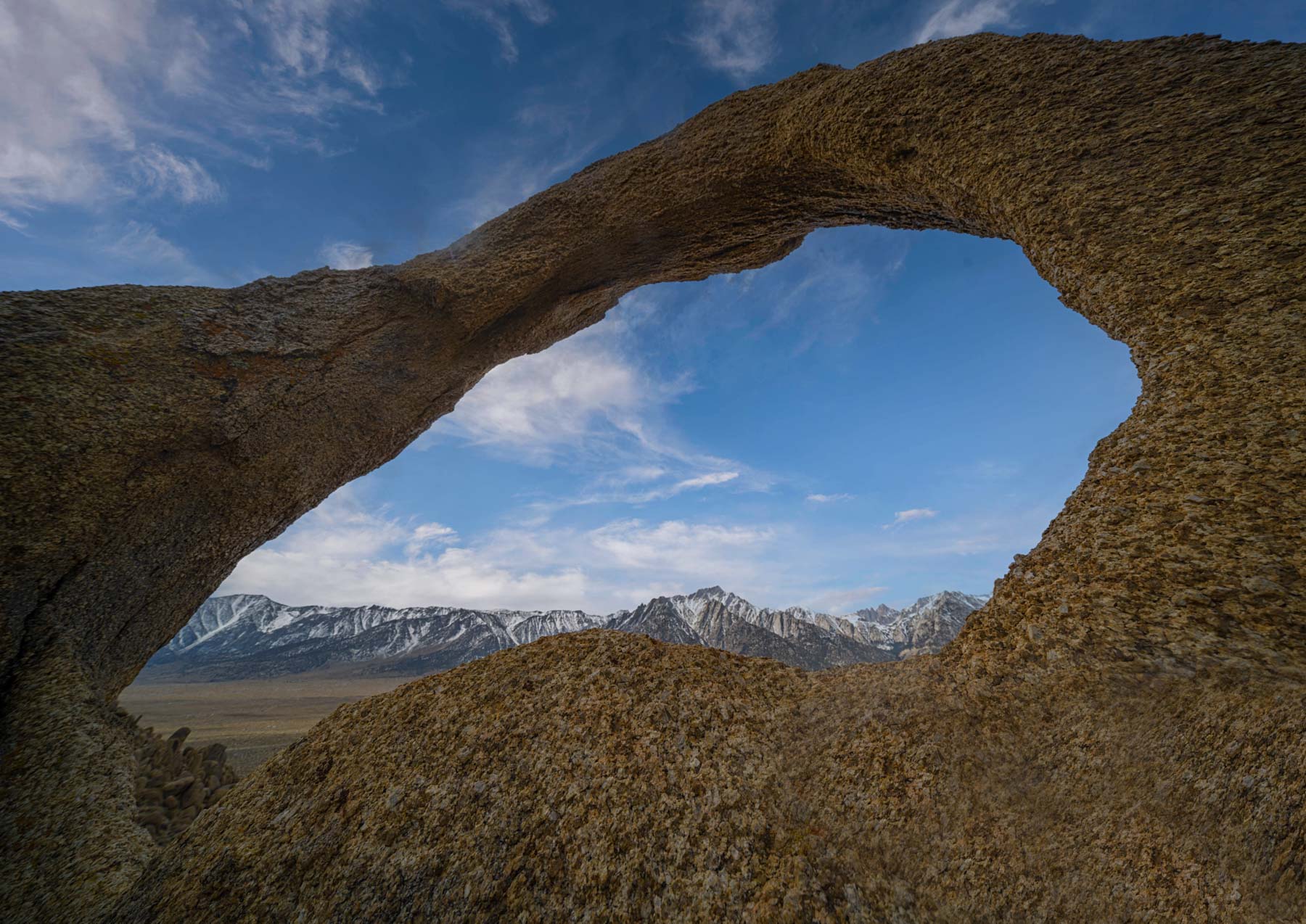
The Alabama Hills is a National Recreation Area managed by the BLM just north of Lone Pine, California. It is a land of potato shaped boulders and myriad arches. Over 400 movies and TV shows have been shot in the Alabama Hills. Mount Whitney is just to the west of Alabama Hills and towers almost 10,000 feet above the hills. Many of the Alabama Hills arches frame Mount Whitney and Lone Pine Peak, also to the west.
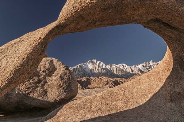
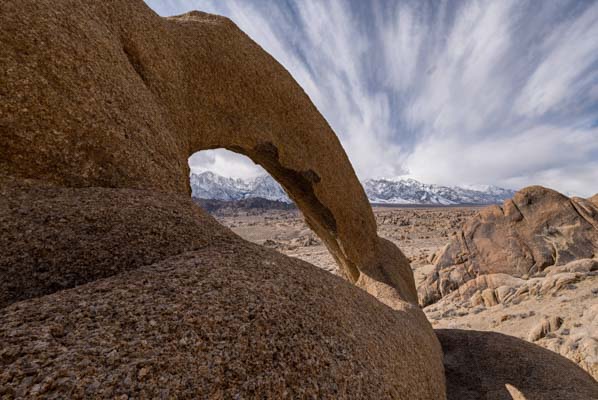
Mobius Arch is the most famous of the Alabama Hills arches. The arch is best at sunrise when its better side is lit and it frames the alpenglow on Mount Whitney and Lone Pine Peak. You are likely to see other photographers at Mobius as well, even at sunrise, and the best area for shooting is small, so get there early, especially on weekends. Getting to Mobius Arch requires a short .25 mile hike over an easy trail. Lathe arch is just to the southwest of Mobius Arch and is best at sunrise as well.
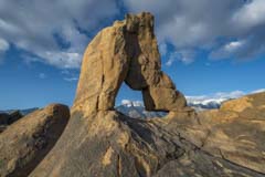
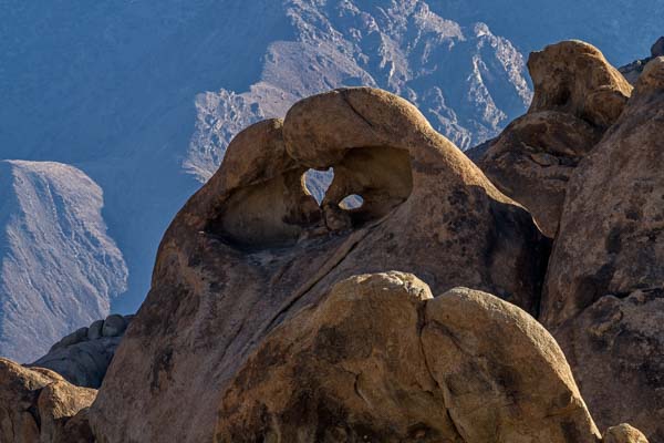
Other photogenic arches within Alabama Hills include the Eye of Alabama, Boot Arch, Cyclops Arch, Hitching Post Arch, Space Case Arch, and Whitney Portal Arch. After Mobius Boot Arch is perhaps the most photogenic arch in the hills. It is good at both sunrise and sunset. At sunrise the alpenglow of the Eastern Sierras fills the background. At sunset the White Mountains east of Owens Valley / Lake provide the background. Boot Arch does not draw the crowds of Mobius. It is also good for Milky Way shots in the late summer and fall. Combine it with Cyclops Arch which is only 0.2 miles away. The Eye of Alabama frames Lone Pine Peak and Mount Whitney when shot from its back side. To access the rear (east side) of the arch hike to its front right side (as seen by you) and turn east. Just after you turn there is an easy scramble up to the arch via a crack. Space Case Arch can be accessed via a short off-tail hike beginning at either the Mobius Arch trail or at the Eye of Alabama trailhead. About twenty feet north from Space Case arch you'll find Baseball Bat arch. It looks more like a corn dog to me. While you can scramble up to Baseball Bat your photos of it won't get any better.

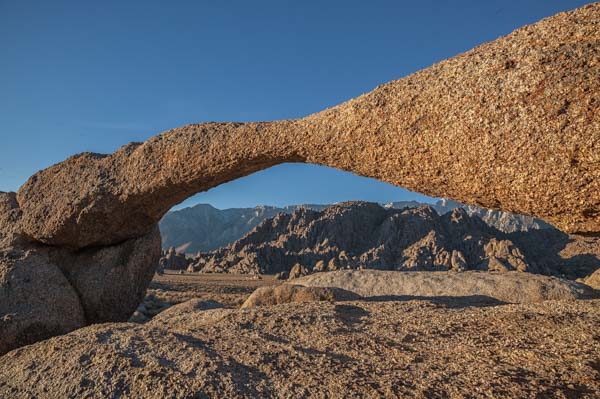
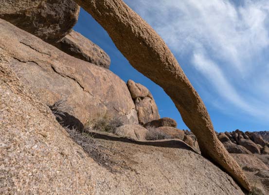
After Mobius Arch and Boot Arch Whitney Portal Arch is perhaps the most photogenic. The arch sits twelve feet above the ground. Good images can be had from ground level, or you can bring an 8 - 10 foot ladder and shoot through the arch to frame Mount Whitney or Lone Pine Peak. The hike to the arch is 0.6 miles one way. The hike is moderately difficult carrying a telescoping ladder as I did. Whitney Portal Arch is best at sunrise for the alpenglow on the Eastern Sierras, or early to mid-morning when the west facing side is lit.
There are over 400 other arches in the Alabama Hills, of which 300 have been documented by Eugene Carsey. His website http://www.eugenecarsey.com/camp/alabamahills/arches.html contains GPS coordinates, images, and travel directions for these 300 arches. Eugene's website is often down; if it is search for a recent copy of his website on the internet archive at https://archive.org/web/ . Another great source of information is the book "Arches of the Alabama Hills" by Orlyn Fordham. It contains the GPS coordinates and good photos of 72 arches within the Alabama Hills National Recreation Area.
When to Go
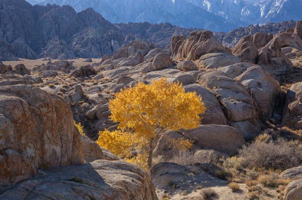
The high desert of Lone Pine is best visited during the spring or fall though winters are reasonable as well with daytime highs in the mid-fifties. Summers are hot and crowded and should generally be avoided unless you are planning to climb Mount Whitney. For me the best time of the year to visit is during November when the cottonwood trees are changing color, the yellow of the trees contrasts nicely with the darkly colored boulders and arches.
Most visitors combine trips to the Alabama Hills with:
- Climbing Mount Whitney - best May to October
- Death Valley - best October to April
- Eastern Sierras Fall Color including Mono Lake, Bodie, Bristlecone Pines, June Lake, Convict Lake, Bishop, Mammoth Lakes, etc. - Best late September to mid-November
- As a stopover driving between southern California and the Mammoth Lakes ski resorts - winter
- Cerro Gordo Ghost Town - good anytime when the road is open
- Trona Pinnacles - best at sunset or night
Climate data for Lone Pine can be found at here.
Where to Stay
The town of Lone Pine is less than five minutes away from the Alabama Hills and has good services with many motels and restaurants. Lone Pine is very camper-friendly. The BLM operates the Tuttle Creek Campground which costs $5 per night. Pit toilets, fire rings, and picnic tables are available. Water is available from March to October. Dump stations are closed in the winter. No reservations.
An even better alternative is dispersed camping available within the Alabama Hills. Camping is free, 14-day limit, first come, first served. Campsites are not marked, but you will find many suitable sites as you drive the many roads within the Alabama Hills. Some of the sites are big enough for large RVs. Sites are scenic and private. The downside - no water, tables, or toilets. Quiet hours are 10 PM to 6 AM. The Google map below contains the locations of over 60 of these campsites within Alabama Hills.
In January of 2021 the BLM published a revised management plan for the Alabama Hills. Following final approval fifty dispersed numbered sites with fire rings will be created as well as a map showing their locations.
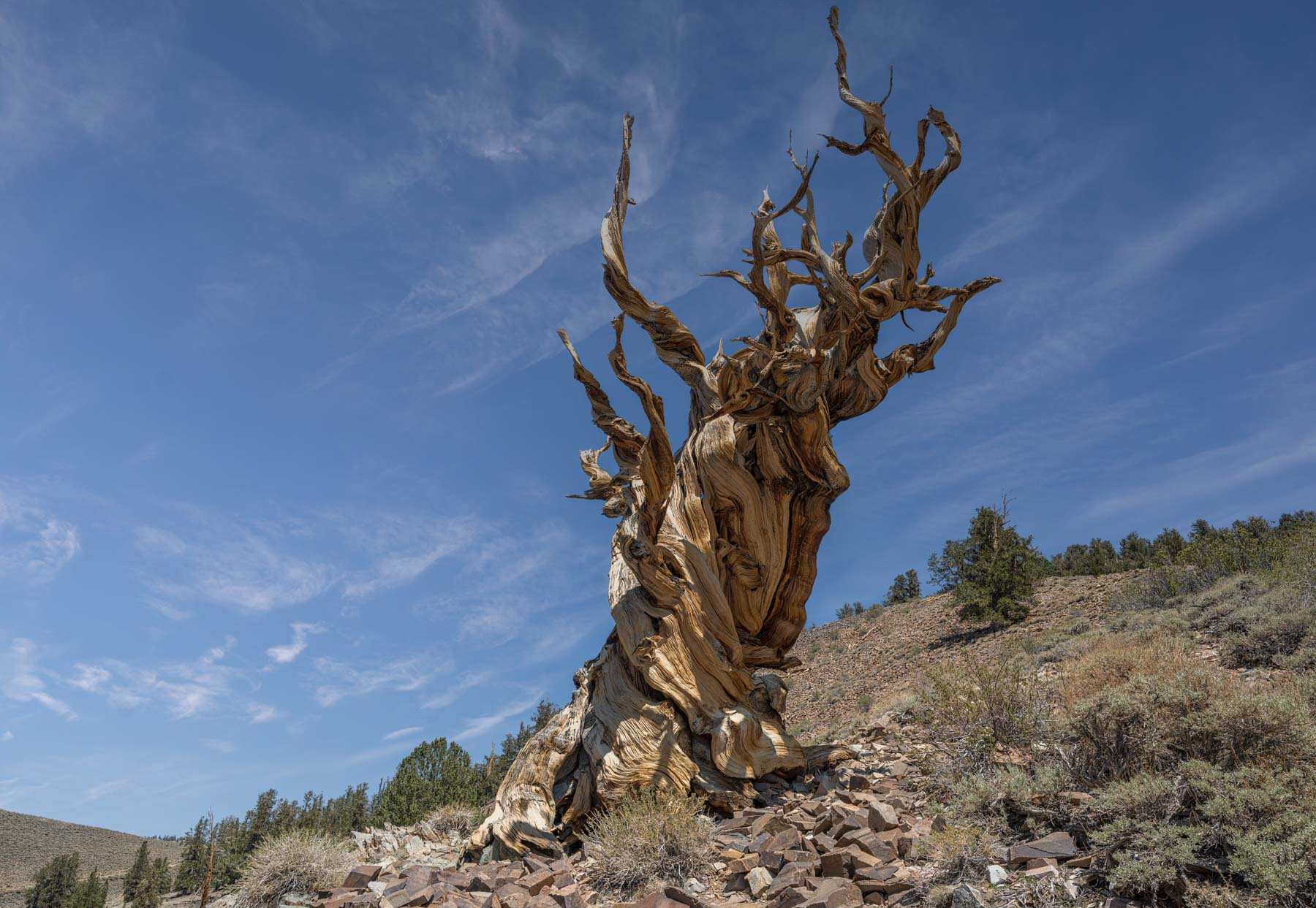
Ancient Bristlecone Pine Forest
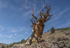
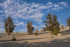
The Bristlecone Pines is home to some of the oldest trees in the world. Some trees are over 4,500 years old. There are two groves of trees. The Schulman Grove is the easiest to access and is the location of the visitor center. The Patriarch Grove is home to the largest Bristlecone Pine, the Patriarch Tree. At the Schulman Grove, be sure to hike the Discovery Trail as there are several photogenic trees, including the "Centennial Tree". The Patriarch Grove is the better of the two groves for photographers as the trees are more isolated. It is an excellent location for shooting under moonlight or as the foreground for the Milky Way. Unfortunately, both the Schulman and Patriarch Groves close at 10 PM. Early closure makes night shooting difficult, especially in June when "astronomical twilight" ends at 10:10 PM. The Schulman Grove lies at 10,000 feet above sea level and the Patriarch Grove at 11,300 feet, so both roads are closed to vehicle traffic in the winter. Call the White Mountain Ranger Station at (760) 873-2500 for current conditions. The road from the visitor center to Patriarch Grove is one lane wide in places. RVs and large vehicles may have difficulty driving it. Uphill traffic has the right of way.
There is no camping in Bristlecone Pines Forest. The nearest town is Big Pine which is an hour away. There is paid camping at the Grandview Campground about 15 minutes from the visitor center. The campground has 23 sites and has pit toilets but no water or electric. $5 per night. The campground fills on weekends in the summer.
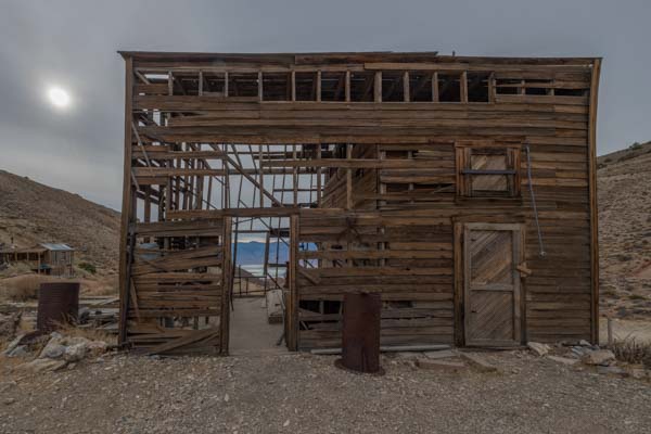
Cerro Gordo Ghost Town
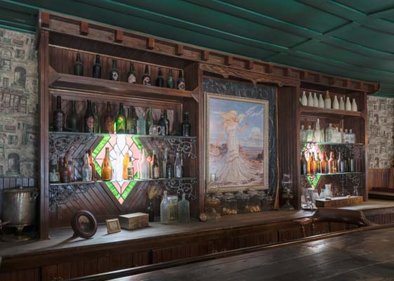
The Cerro Gordo Mines form the basis of a small ghost town about 45 minutes from Lone Pine. There are several largely intact buildings remaining. Unfortunately, The American Hotel burned down in June of 2020. It is under reconstruction. As of December 2020, the basement had been dug and leveled. The American Hotel was the most photogenic of the buildings, especially its insides. Before visiting Cerro Gordo call Robert Desmarais, the property manager, at 760 876-5030 and ask about road conditions.
Cerro Gordo ghost town is 8,500 feet in elevation and is accessed via Cerro Gordo Road. Cerro Gordo Road is a packed dirt road. A 2WD vehicle is normally sufficient, except following rain or in the winter after a snowfall. While the road is not difficult to drive, it is steep, narrow, and contains drop-offs. Some will be uncomfortable driving it. Cerro Gordo Road continues past the ghost town to Saline Valley Road. 4WD low is required to continue to Saline Valley as the road becomes very rocky with wash-outs.
To get to Cerro Gordo from Lone Pine, drive south on US 395 / Main Street to CA 136. Turn left at the intersection and drive 13.0 miles (just past the town of Keeler) to Cerro Gordo Road. Turn left and drive 7.7 miles on Cerro Gordo Road to the ghost town.
Cerro Gordo is privately owned and only gets a few visitors per day. It is open every day from 9 AM to 4P M in the winter months and from 9 AM to 5 PM when daylight savings time is in effect. Admission is $15 per person. You must sign a liability waiver form. The website cerrogordomines.com contains more information about access. Cerro Gordo was sold in late 2018 but remains open to the public. As of March 2021, you can pay the admission fee when you get to Cerro Gordo.
Although the American Hotel is no more, the interiors of the Assay Office and the museum are worth shooting. You can skip the bunkhouse as it has been renovated. The remains of the Ice House frame dry Owens Lake in the far distance.
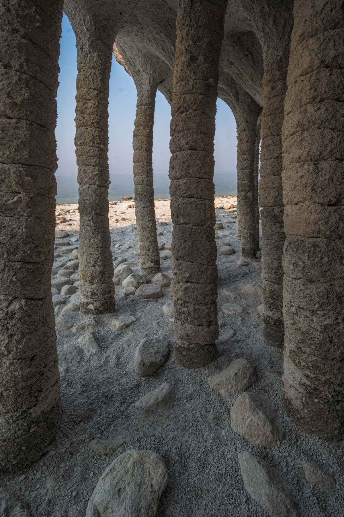
Crowley Lake Stone Columns
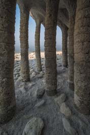
The Crowley Lake Stone Columns are a spectacular curiosity on the east side of Lake Crowley. When I was there last August, heavy smoke from the Dixie Fire made shooting at sunset worthless. The smoke cleared some overnight, so shooting at dawn was okay. In my opinion, both sunrise and sunset will normally work well here. At dawn, the columns are in shadow, making shooting easy. At sunset, you will have mixed light. Mixed-light makes shooting more difficult but may make for more dramatic photos. The Crowley Lake area is becoming well known, and you are likely to have other people in your image if you shoot late day. At sunrise, I had the columns to myself for over an hour.
You will need an ultrawide or a pano head and rail to best capture the columns from the inside of the caves. You will be shooting quite close to the columns. If you shoot a panorama, center your lens on the nodal point, or your images will not stitch.
The Crowley Lake columns are best shot from May through November, provided the water level in the lake is low enough. The columns are at roughly 6785 +- 10 feet. If the water level is above 6780 feet, the columns may be inaccessible or underwater. Jessica Fridrich recently told me that a water level gauge for the lake is available from the LA Department of Water and Power. Alternatively you can call the LADWP at 760 873 0251 8-4pm Pacific time. In the winter, Crowley Lake is likely to be inaccessible. Highway 395 occasionally is closed due to snow, and the steep hills on the road to Crowley Lake may be impassable.
To get to Crowley Lake from Bishop, take Highway 395 north to Tom's Place and turn right onto Owens Gorge Road. Continue six miles on the good 2WD road until you get to a steep, wide, heavily rutted hill. Park here if you do not have a high clearance 4WD vehicle. The hike/drive from here to the 4WD trailhead is about 1.7 miles one way. Continue up the hill .95 miles and turn left onto Forest Rd 4S45. After 200 feet, turn right onto an unnamed road and continue straight for about .6 miles to a small 4WD parking area. The hike from here to the columns is very short. From the 4WD parking area, hike slightly west of north down the hill to the beach. The best columns are easily visible from here. The columns extend 1/4 to 1/2 mile north up the beach and may be accessible depending on the water level. You can probably access the columns by boat as well. If you wish to rent a boat, contact Crowley Lake Fish Camp at (760) 935-4301 during fishing season (end April through October).
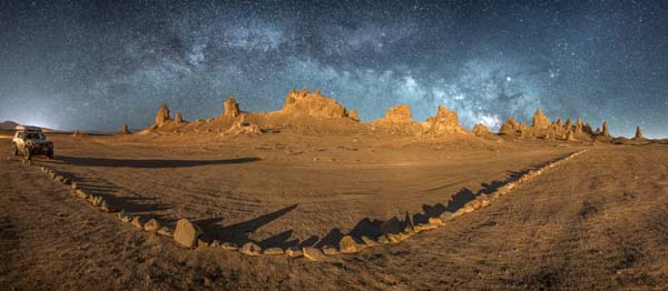
The Trona Pinnacles
The Trona Pinnacles are about 90 minutes south of Lone Pine. They are an excellent destination for night photography. From late February through early August you can capture the full span of the Milky Way over the Pinnacles using an ultra-wide lens and a panorama head. Shoot a composite of two images during the moon's 3rd quarter. For the first image the moon, setting to the west, will light up the west facing pinnacles. Shoot the second image of the Milky Way after the moon has set and combine both in Photoshop. Alternatively you can try to light paint the pinnacles while the Milky Way is up, this is difficult when shooting a panorama.
| Date | Time Visible | Elevation |
|---|---|---|
| 3/1 | 2:26 AM | 0° |
| 4/1 | 1:23 AM | 0° |
| 5/1 | 11:25PM | 0° |
| 6/1 | 9:46PM | 3.3° |
| 7/1 | 9:57PM | 19.7° |
| 8/1 | 9:32PM | 25.3° |
The pinnacles are also a good destination at sunset when good clouds are present. To get to the Trona Pinnacles from Lone Pine, take US395 70 miles south to exit 97 - California 178 and turn left. Continue on 178 4.5 miles to Jacks Ranch Road and turn right. Take Jacks Ranch Road 2 miles and turn left onto Ridgecrest Blvd. Continue on Ridgecrest Blvd / CA 178 for 19.7 miles and turn right onto Pinnacle Road. Follow Pinnacle Road for six miles to the main parking area. Good lodging is available in Ridgecrest (population 29,000), and dispersed camping is available at the Pinnacles. Late February through early June is the best time to visit the Pinnacles as temperatures are pleasant, and the full arc of the Milky Way will be visible.
Google map of the Alabama Hills, Trona Pinnacles, and Cerro Gordo Ghost Town
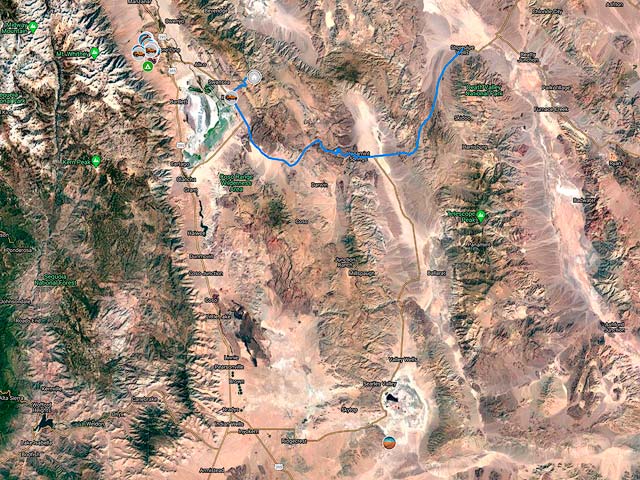
To view the map in Google Maps please click anywhere on the map above.
- Click to download a KMZ file (Note - in IE Right Click and choose Save Target as)
- Click to download a KML file (Note - in IE Right Click and choose Save Target as)
- Click to download a GPX file (Note - in IE Right Click and choose Save Target as)
Google map of the Ancient Bristlecone Pine Forest and Crowley Lake
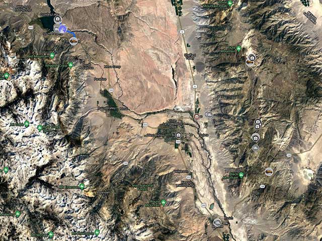
To view the map in Google Maps please click anywhere on the map above.
- Click to download a KMZ file (Note - in IE Right Click and choose Save Target as)
- Click to download a KML file (Note - in IE Right Click and choose Save Target as)
- Click to download a GPX file (Note - in IE Right Click and choose Save Target as)
Dark Sky Map of the Alabama Hills Area
The following map from darksitefinder.com gives a rough idea of how dark the skies are in the Alabama Hills area. Click on the map below to zoom in or out or change the base layer:
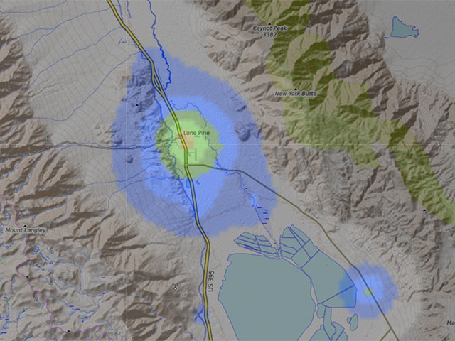
The map contains 15 colors. The Milky Way is invisible in the white, light gray, and red areas, visible but washed out in the yellow and orange areas, shows the Milky Way's structure in the green and blue areas, and in the black area, light from the Milky Way center casts shadows. Here's more information about how to interpret the colors on the map. This information comes from handprint.com:

USGS 24K Topo Maps
Alabama Hills is covered by the Lone Pine, Manzanaro, Mount Langley, and Union Wash maps. A merge of these four maps is available below. The Lone Pine GeoTiff on both Topoquest and libremap.org is corrupt so I downloaded the GeoPdf from the USGS National Map Server and converted it to a GeoTiff. All four maps above and the merge map can be downloaded in a variety of formats by clicking or right clicking below.

Alabama Hills Index Map
Alabama Hills Topographic Maps
| Geo Tiff/Avenza | KMZ | Oruxmaps | KMZ Decollared | Oruxmap Decollared | Avenza Decollared |
| Lone Pine | KMZ | Oruxmap | KMZ Decollared | Oruxmap Decollared | Avenza Decollared |
| Manzanaro | KMZ | Oruxmap | KMZ Decollared | Oruxmap Decollared | Avenza Decollared |
| Mount Langley | KMZ | Oruxmap | KMZ Decollared | Oruxmap Decollared | Avenza Decollared |
| Union Wash | KMZ | Oruxmap | KMZ Decollared | Oruxmap Decollared | Avenza Decollared |
| Merge of all four maps | NA | NA | KMZ Decollared | Oruxmap Decollared | Avenza Decollared |
Bristlecone Pines Topographic Maps
| Geo Tiff/Avenza | KMZ | Oruxmaps | KMZ Decollared | Oruxmap Decollared | Avenza Decollared |
| Blanco Mountain | KMZ | Oruxmap | KMZ Decollared | Oruxmap Decollared | Avenza Decollared |
| Mount Barcroft | KMZ | Oruxmap | KMZ Decollared | Oruxmap Decollared | Avenza Decollared |
| Merge of both maps | NA | NA | KMZ Decollared | Oruxmap Decollared | Avenza Decollared |
Cerro Gordo Topographic Map
| Cerro Gordo Peak | KMZ | Oruxmap | KMZ Decollared | Oruxmap Decollared | Avenza Decollared |
Crowley Lake Topographic Map
| Toms Place | KMZ | Oruxmap | KMZ Decollared | Oruxmap Decollared | Avenza Decollared |
Trona Pinnacles Topographic Map
| Christmas Canyon | KMZ | Oruxmap | KMZ Decollared | Oruxmap Decollared | Avenza Decollared |