Ah-shi-sle-pah
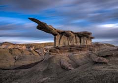
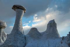
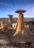
Photography in the Ah-Shi-Sle-Pah Wash in New Mexico offers a surreal and otherworldly experience, where the landscape is dominated by eroded badlands, striking hoodoos, and richly textured rock formations. This remote and largely untraveled area between Chaco Canyon and Bisti/De-Na-Zin Wilderness provides a dramatic palette of earth tones, from ochres and grays to deep reds, especially vivid during sunrise and sunset. The sculpted terrain invites creative compositions, while the silence and isolation enhance the immersive experience for photographers seeking to capture the raw beauty of the high desert.
There are three areas of photographic interest in the wash: the Wilderness area (WA) on the south side of the wash, the King of Wings (KOW) area on the north side, and the Valley of Dreams (VOD) also on the south side but outside the WA. On my last trip, I tried to reach VOD by memory, which proved faulty. I ended up about a mile east of VOD. I found a fourth group of mudstone hoodoos called Valley of Dreams East. This area has many hoodoos and capped mudstone formations, all in a small area. You used to be able to drive right to the eastern hoodoos, but the Navajo have closed the roads to the area. It can still be visited by starting elsewhere in the wash and hiking to it.
All four areas of Ah-shi-sle-pah are within hiking distance of each other. Going to all four would make for a very long day, and you would miss the golden hour at some of them. You should spend a day at each to explore and get the good light of sunrise and sunset. In addition to these four areas, the remainder of Ah-shi-sle-pah is worth exploring, and I am sure there are many other formations yet to be "discovered".
Where to stay
Farmington has many hotels and good restaurants. Farmington is within an hour of Shiprock and Aztec National Monument. These are both worth shooting. You should leave Farmington about two hours before sunrise to arrive at the WA / KOW/ VOD in time for sunrise. You must hike about one mile to get to the KOW and wilderness area formations. If you plan to shoot sunrise, you may want to scout these locations the day before.
Backcountry camping is permitted on BLM land in the area. Car camping is allowed on BLM land outside the wilderness area. Land ownership is shown in the following map:
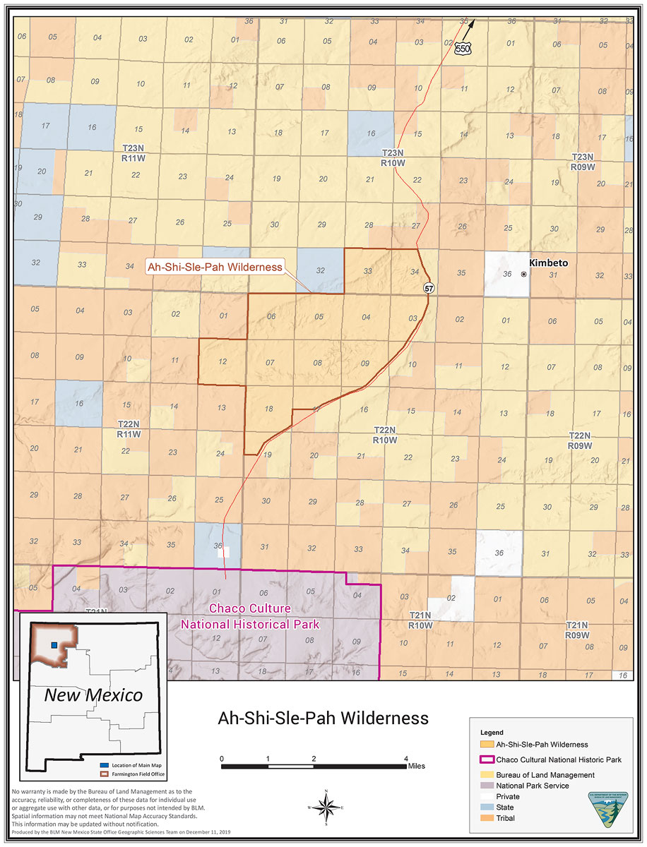
The BLM graciously provides a geopdf version of the map on their website. Mapc2mapc can be used to convert it to a variety of other formats, such as a kmz file viewable in Google Earth.
The numbered areas above are called sections and are one square mile (640 acres). The blocks of 36 sections are called townships. A township is 6 miles square (36 square miles). Sections are used on maps showing land ownership. Western land rights were frequently granted by the section, quarter section, sixteenth of a section, etc. Some western USGS 24K topo maps show sections, townships, latitude, and longitude. Maps with sections allow you to relate land ownership to latitude and longitude. The BLM and the Navajo Nation own most of the land in Ah-Shi-Sle-Pah Wash. Most of Ah-shi-sle-pah is on the Pueblo Bonita NW 24K map. This map shows section boundaries. Combining the land ownership map above with the Pueblo Bonita NW 24K topo map implies land is owned as follows:
- Wilderness Area: The parking and wilderness areas are on BLM land. You can car camp near the parking area or backpack into the WA and camp there. You cannot fly a drone in the wilderness area.
- KOW: The King of Wings is on BLM land, as is the wash below it. It is not in the wilderness area, so you can backcountry camp there. Remarkably, you can fly a drone there. Please do not camp right at the KOW. Camp at least 100 yards away or in the wash. The trailhead to the KOW is on BLM land just outside of tribal lands. I believe car camping there is allowed, but not advised.
- VOD and VOD East: The parking area and formations are largely on tribal lands. I recommend you do not camp there.
Note - to access KOW or VOD, you must drive or hike on Native American land. Please respect it. Please do not walk on crops, approach animals, tear up roads by driving on them in poor weather, or drive off-road. Leave gates as you find them, closed if closed, open if open. Leave no trace. The Native Americans living near Ah-shi-sle-pah practice subsistence farming/ranching. Small herds of cows, horses, goats, and sheep are common. Refrain from disturbing their traditional way of life, or we will lose the ability to visit these areas. Closures have happened in other areas, such as Grand Falls (closed 3/1/23) and the land owned by the Kaibeto chapter in Arizona.
When to Go
At 6,000 feet plus winters are cold at Ah-shi-sle-pah, and summers very warm. The Four Corners area can be very windy, and dust storms are common in the Spring. June is dry, and winds have largely subsided. It is a good month to visit if you are okay with clear skies or want to shoot the Milky Way. If it rains too much during the summer, roads will be impassable, and you cannot hike on the clay-based soils. The best season is autumn; temperatures and winds are moderate, and the monsoon season has largely passed.
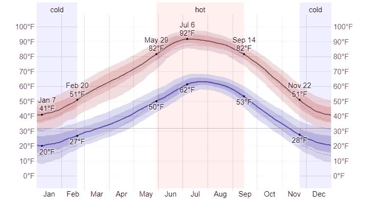
Average High and Low Temperature in Farmington, NM - © Weatherspark.com
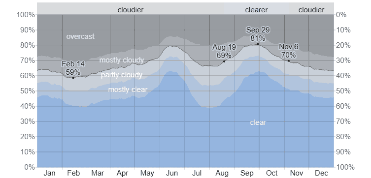
Average Cloud Cover in Farmington, NM - © Weatherspark.com
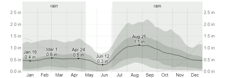
Average Monthly Rainfall in Farmington, NM - © Weatherspark.com
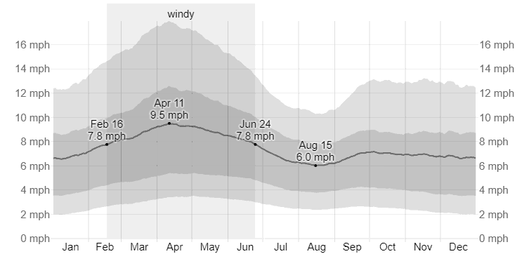
Average Wind Speed in Farmington, NM - © Weatherspark.com
Getting There
King of Wings
- From Farmington, take NM 371 45.5 miles south of NM 371 and the San Juan River to the intersection of NM 371 and CR 7650.
- CR 7650 is a gravel road for the first few miles and then turns to packed dirt/clay. The road is suitable for passenger cars when dry. When wet, it is easy to get stuck, no matter what vehicle you have. Take CR 7650 10.1 miles and turn right onto a sandy Jeep road. There is a cattle guard just before the turn.
- Take the jeep road 2.1 miles to where it turns east. There is a barbed wire fence along the south edge of the road. Park anywhere here.
- The hike to the KOW is 0.9 miles due south from where you park. There are no trails. Please route yourself to the KOW using your GPS and carefully follow the heading, or follow the track in the map below. By following the heading carefully or the track, you will avoid some dead ends and backtracking. To start your hike, go under the barbed wire fence and cross the grassy field following the southerly heading in your GPS. After about 1600 feet, you will reach an area of Chinle (Bentonite) badlands. The badlands will be difficult to cross if wet, and many small washes crisscross them. The washes range from an annoyance to impossible to cross, so I suggest you spend as little time on the Chinle as possible. On entering the Chinle rolling hills, you will see another grassy knoll about 1000 feet to the south, aim for it, and hike across the knoll. After leaving the knoll, proceed south again across the Chinle for another 1000 feet to reach the King of Wings. The KOW can only be seen once you are quite close to it. Some other good photo ops near the KOW lie in the wash below and to the northeast.
Valley of Dreams / East
- From Farmington, proceed to CR 7650 as above. Take CR 76560 7.8 miles and turn right onto CR 7870. CR 7870 is a good dirt road.
- Take 7870 to GPS location 36.12427 N, 107.98073 W, and turn left on a dirt road. After 0.4 miles, bear left. At 1.1 miles, a road comes in from the left. To get to Valley of Dream parking, take the left for about 0.2 miles and park in teh large open area to begin your hike north.
- Valley of Dreams East is accessible from VOD; hike in a SSE direction for a bit over a mile, staying in the wash.
Ah-shi-sle-pah Wilderness Area
- This area is best approached from the east using US Highway 550 from Bloomfield.
- From the intersection of US 64 and US 550 in Bloomfield, proceed south 28.3 miles to the intersection of US 550 and SR 57.
- Turn right on SR 57 and continue 18.3 miles and park on SR 57 near the closed road heading north.
- On foot, follow the old road 0.6 miles to an overlook of the WA.
- You're on your own from here!
Shooting Tips
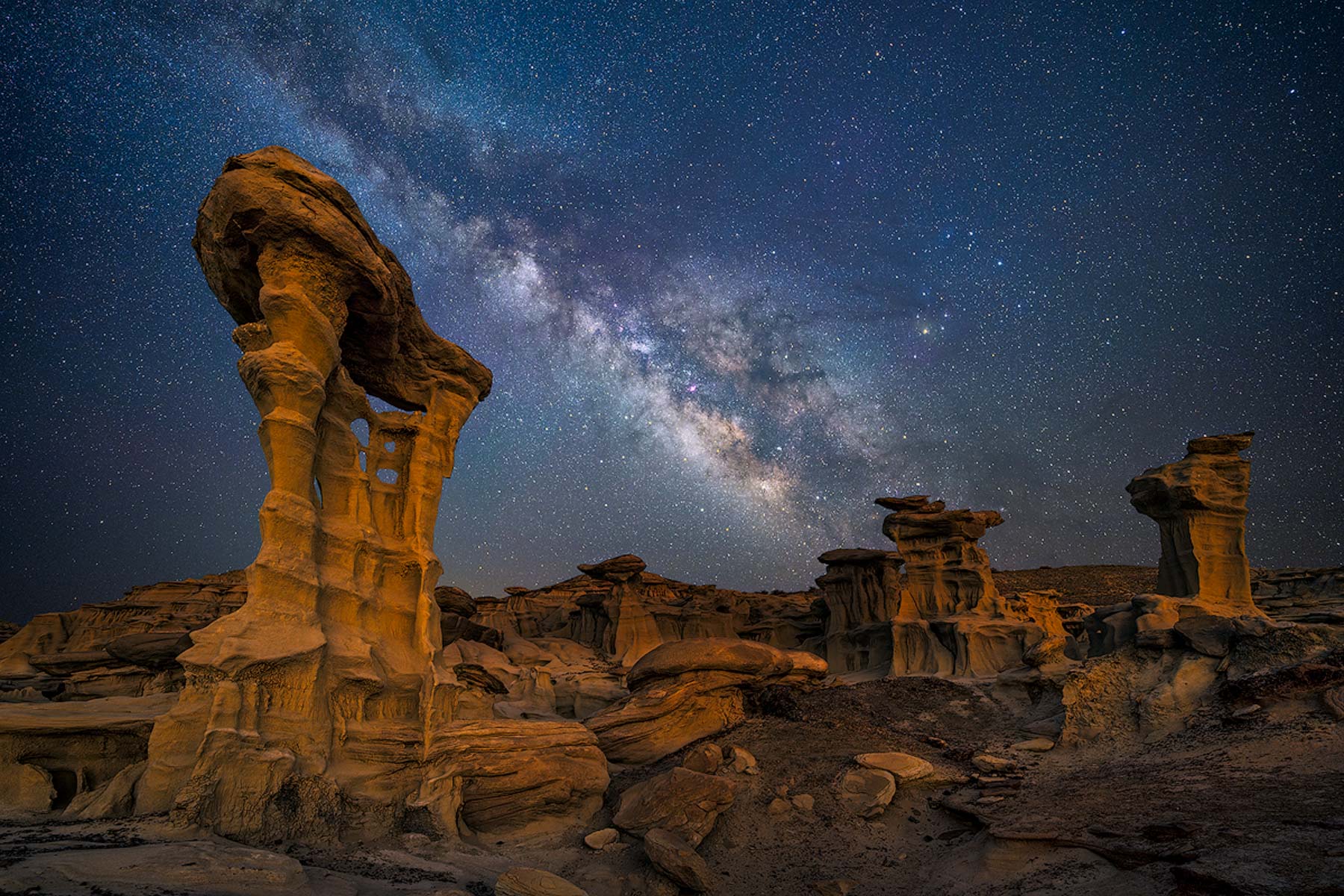
All three areas get good light at sunrise and sunset and in the blue hour. The King of Wings is slightly better at sunset than sunrise, but see the gallery pictures and judge for yourself. You'll need a wide-angle lens to shoot KOW from the south side of the blade; 14-24 mm works well. Remember, wide angles emphasize the foreground. If you want a long blade, shoot at 14mm from close up. The KOW is an excellent location for Milky Way photography. The Alien Throne is also good for Milky Way shots.
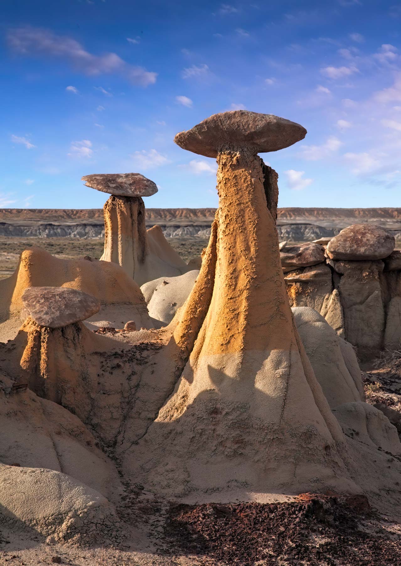
On your way to the Alien Throne, stop at the Three Wise Men, the Mushroom Seat, and Hourglass Hoodoo. The Three Wise Men is nicely framed by the Milky Way 3 - 4 hours after the galactic center rises. The Alien Hatchery (Big Mushroom) and the Stone Camel are good subjects closer to the Alien Throne.
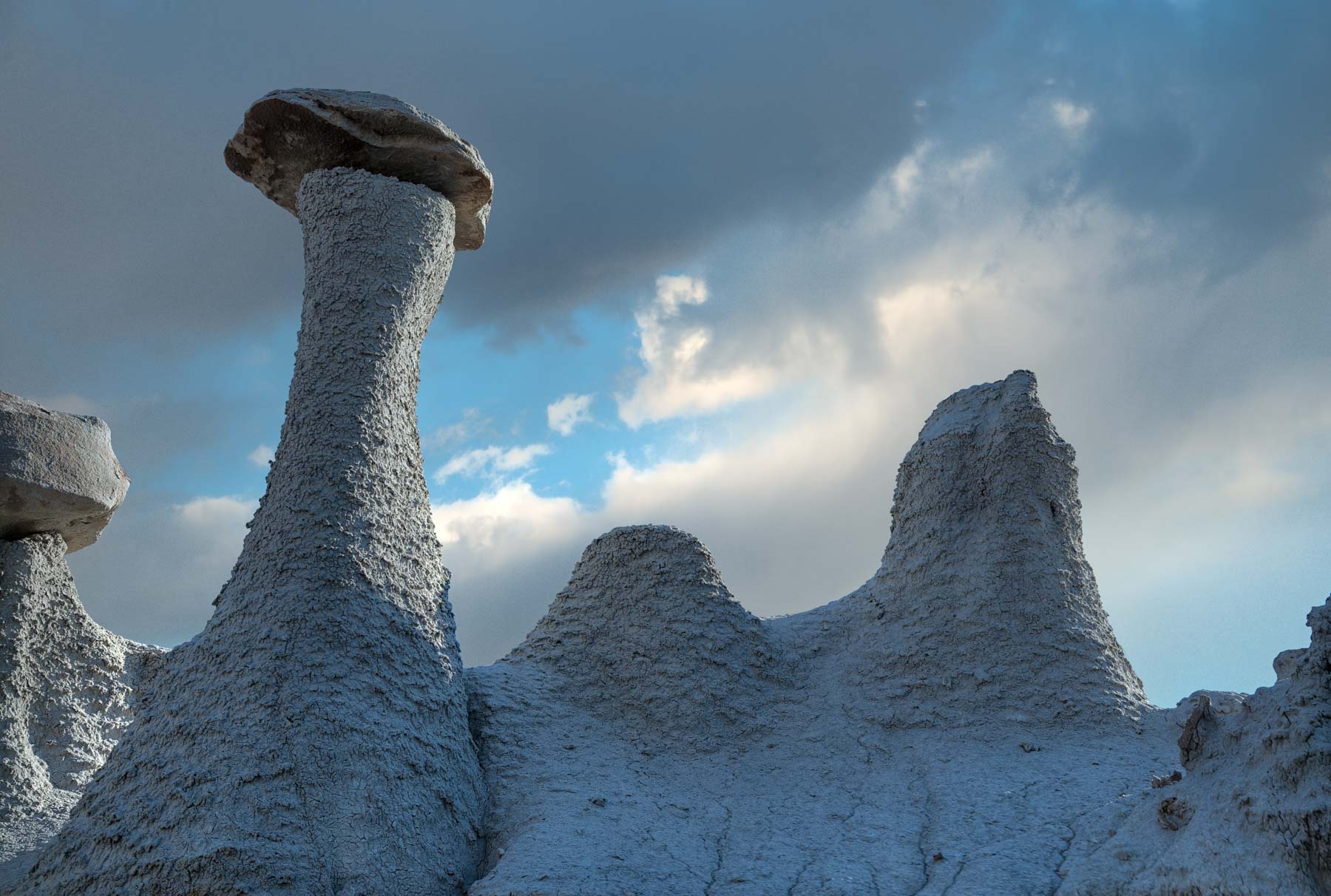
The Yellow Hoodoo Gang is a great subject within the wilderness area at sunrise and sunset. Access is mildly difficult; I approached it directly from the south, roughly following the light blue line on my Google Map. There is also a little gully just to the west that goes. Other good subjects in the area include the Chocolate Mushroom Hoodoos, the rock garden, and The Goblet to the north. The area has many petrified logs; most are not good subjects, but the petrified stump at 36.15321, -107.93967 is quite photogenic.
I've seen wild horses in each of my last four trips to the area. They are a captivating subject when seen running with hoodoos in the background. When hiking in the area, have a long telephoto (100-400) on your camera and be ready to shoot action with a shutter speed of at least 1/1200 of a second.
Maps
Here is an overview map showing all three areas and routes into Chaco Canyon. The wilderness boundary is also shown, as is the boundary of Chaco Canyon National Historical Monument; remember, no drones or cars in the wilderness or on NPS lands:
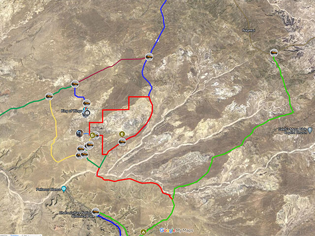
To view the map in Google Maps, please click anywhere on the map above.
- Click to download a KMZ file (Note - in IE Right Click and choose Save Target as)
- Click to download a KML file (Note - KML files do not include custom icons)
- Click to download a GPX file (Note - in IE Right Click and choose Save Target as)
Dark Sky Map of Ah-Shi-Sle-Pah
The following map from darksitefinder.com gives a rough idea of how dark the skies are in the Ah-Shi-Sle-Pah area. Click on the map below to zoom in or out or change the base layer:
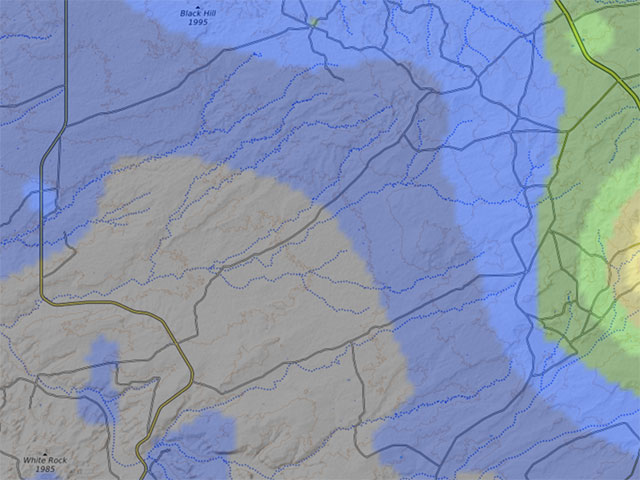
The map contains 15 colors. The Milky Way is invisible in the white, light gray, and red areas, visible but washed out in the yellow and orange areas, shows the Milky Way's structure in the green and blue areas, and in the black area, light from the Milky Way center casts shadows. Here's more information about how to interpret the colors on the map. This information comes from handprint.com:

USGS 24K Topo Maps
Two topographic maps cover the entire area of interest: Pueblo Bonita NW covers Ah-shi-sle-pah wash, and Pueblo Bonita covers Chaco Canyon. They can be downloaded in a variety of formats by clicking or right-clicking below:
| Geo Tiff/Avenza | KMZ | Oruxmaps | KMZ Decollared | Oruxmap Decollared | Avenza Decollared |
| Pueblo Bonito NW | KMZ | Oruxmap | KMZ Decollared | Oruxmap Decollared | Avenza Decollared |
| Pueblo Bonito | KMZ | Oruxmap | KMZ Decollared | Oruxmap Decollared | Avenza Decollared |
| Merge of both maps | NA | NA | KMZ Decollared | Oruxmap Decollared | Avenza Decollared |