Yant Flat
Yant Flat is located in the southwest part of Utah between St. George and Leeds. It is about 25 miles by car from St. George. If you are staying in St. George, Hurricane or Springdale and need a break from the crowds of Zion it is a good destination for the day.
When to Go
The elevation of Yant Flat is about 4,600 feet. Yant Flat's temperatures should be 5-8 degrees colder than those of St. George which is at 2,900 feet. St. George has mild winters and hot summers. December to March are the wettest months of the year in St. George with snow possible. Any snow would melt quickly. Late May is an excellent time to visit Yant Flat as the wildflowers (Yucca, Cactus, and various Asters) will be in bloom. Yant Flat opens to the southeast so sunrise normally gets better light than sunset. Sunset gets reasonably good light as well.
St. George Climate
| Max. Temp (°F) | Min. Temp (°F) | Precipitation (in.) | SnowFall (in.) | |
| Jan | 53.6 | 25.8 | 1.07 | 1.3 |
| Feb | 59.9 | 30.6 | 1.02 | 0.6 |
| Mar | 67.9 | 36.3 | 0.93 | 0.2 |
| Apr | 76.7 | 43.1 | 0.53 | 0 |
| May | 86.1 | 51.1 | 0.39 | 0 |
| Jun | 96.2 | 59.1 | 0.19 | 0 |
| Jul | 101.7 | 66.5 | 0.67 | 0 |
| Aug | 99.5 | 65.2 | 0.76 | 0 |
| Sep | 92.6 | 55.4 | 0.6 | 0 |
| Oct | 80.2 | 43.3 | 0.68 | 0 |
| Nov | 64.8 | 32 | 0.64 | 0.2 |
| Dec | 54 | 25.9 | 0.77 | 0.9 |
| Annual | 77.8 | 44.5 | 8.25 | 3.2 |
Getting There
From St. George proceed north on I15 to exit 22. Proceed 1.7 miles on South Main Street and turn left onto Silver Reef Road. After 1.2 miles Silver Reef Road becomes Oak Creek Road. Proceed on Oak Creek Road for an additional 2 miles and bear left onto Forest Service Road 031. A high clearance vehicle is desirable but not required on this road. This road has steep drop-offs and some clay sections. It is impassable when wet to all vehicles. Proceed on the FS road for 7.3 miles to the trailhead. The trailhead has room for nine to twelve cars and is largely on the left side of the road. There is some space on the right side as well. If parking is unavailable at the trailhead other nearby parking is readily available.
If you are coming from the north on I15 take exit 23 and bear right at the exit onto Silver Reef Road. Then follow the directions above. Note that exit 23 is only open to southbound vehicles, vehicles coming from St. George should take exit 22.
The Hike: Proceed south from the trailhead following the now closed dirt road for about one mile. After one mile leave the road and make your way 0.4 miles SSE off trail to an overlook of Yant Flat at 37.218333, -113.467500. Descend down the small sand dune to begin your explorations of the area. The map below shows the track that I took on my visit. It is by no means optimal.
Google Map
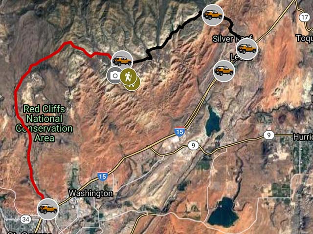
To view the map in Google Maps please click anywhere on the map above.
- Click to download a KMZ file (Note - in IE Right Click and choose Save Target as)
- Click to download a KML file (Note - KML files do not include custom icons)
- Click to download a GPX file (Note - in IE Right Click and choose Save Target as)
USGS 24K Topo Maps
The topo map Harrisburg Junction covers the area of interest. This map can be downloaded in a variety of formats by clicking or right-clicking below:
| Geo Tiff/Avenza | KMZ | Oruxmaps | KMZ Decollared | Oruxmap Decollared | Avenza Decollared |
| Harrisburg Junction | KMZ | Oruxmap | KMZ Decollared | Oruxmap Decollared | Avenza Decollared |