Coal Mine and Ha Ho No Geh Canyons
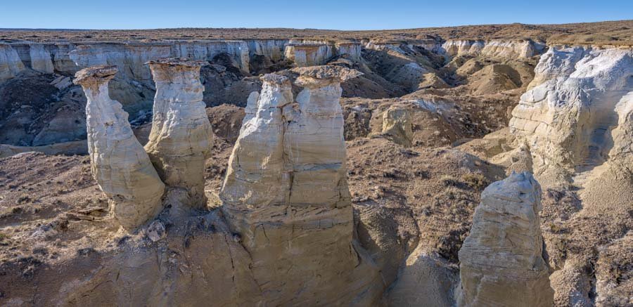
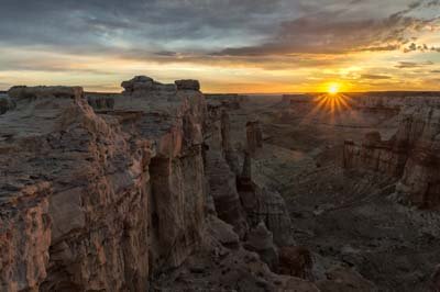
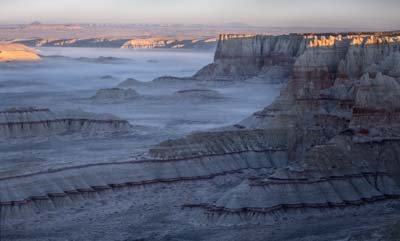
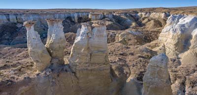
The colorful formations in the canyons south of Tuba City are among the most photogenic in the United States. These canyons include the well-known if somewhat remote Coal Mine Canyon, and the infrequently visited Ha Ho No Geh Canyon. Also in the area is a hoodoo capped by a perfectly round rock known to me as Globe or Round Rock. The Coal Mine and Ha Ho No Geh drainages contain countless hoodoos, pinnacles, and towers interspersed along a red and white striped rim. Except for the canyons the area is largely flat so in the summer the area is ideal for shooting dramatic weather and lightning.
Coal Mine Canyon
Coal Mine Canyon is a tributary of Moenkopi Wash and is about fifteen miles southeast of Tuba City, Arizona. Coal Mine Canyon contains red and white striped cliffs and is most easily shot from the rim. The rim is on Navajo Nation land. The interior of the Coal Mine Canyon is part of the Hopi Nation and a Hopi guide is required to descend to the interior. There is a trail near the parking area from the canyon rim to the interior. The trail is difficult. I have shown an approximate route to the bottom of Coal Mine Canyon on the map below.
The rim of Coal Mine Canyon is in the Navajo Nation and a permit is needed to visit it. The permit can be obtained in Cameron at the Cameron Visitor Center located at the intersection of Highways 89 and 64 (SW corner). The visitor center is open five days a week from 8AM to 5:30 PM during the winter months. You should call +1 928 679-2303 for summer hours. Permits are also available by mail; apply well in advance of your trip date. See the Navajo Nation Parks website for more details. Permits fees were recently increased to $12.00 US per person per 24 hour period. The permit allows camping overnight also. There are picnic tables in poor condition at the parking area but no toilets or water.
If you wish to descend into Coal Mine Canyon legally you will need both a Navajo Nation permit to access the rim and a Hopi guide for the interior. For information on Hopi guided tours visit http://www.experiencehopi.com/authorized-hopi-guides. The site http://www.experiencehopi.com/faq has some additional information about hiking in the Hopi Nation.
Coal Mine Canyon East and Ha Ho No Geh Canyon
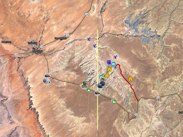
There are other canyons of interest in the area of Coal Mine Canyon. The turnoff to Coal Mine Canyon East is exactly three miles east-southeast of the Coal Mine Canyon turnoff. After the turnoff follow the route shown in green and red on the map below. The road in green neatly divides the Coal Mine and Ha Ho No Geh drainages. Views to the west are of Coal Mine, and views to the east are of Ha Ho No Geh. Ha Ho No Geh wash flows northwest into Coal Mine wash. Both then flow into Moenkopi Wash followed by the Little Colorado river. Ha Ho No Geh is just as spectacular as Cola Mine Canyon, but is less often visited as the 4x4 road is longer and the canyon is entirely within the Hopi Reservation. Ha Ho No Geh is full of hoodoos and towers. It seems to have far more than the more easily visited Coal Mine Canyon. Ha Ho No Geh is twelve scenic miles long. The rim, because of its many ins and outs, is probably twice that. This makes it very difficult to find the best shooting locations, especially in the areas not serviced by dirt roads. So far I've only been able to find a few good locations, I'm sure there are many many more. Bat Canyon, east of Ha Ho No Geh, is a tributary of Ha Ho No Geh Wash and may be worth a shot. Coal Mine Canyon East, Ha Ho No Geh, and Bat Canyon are entirely within the Hopi Nation and a Hopi guide is required. I have shown a route to the bottom of lower (northern) section of Ha Ho No Geh Canyon on the map below. Access is via an old road which is probably impassable to vehicles now.
Other Places to Visit
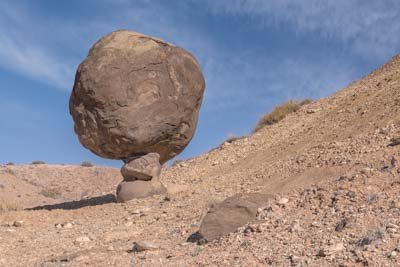
While in the Tuba City area there are many other places to stop at. There is a balanced round rock (Globe Rock) in the Navajo Nation seven miles south of Tuba City. I estimate the rock to be four feet in diameter with a weight of two tons. It is supported by a pedestal only one foot in diameter! There are several other round rocks in the area, but only Globe Rock is still on a pedestal. Globe Rock is shown as "Balanced Rock" on the USGS Moenkopi 24K topographic map. Globe Rock is best shot in the winter months near sunrise ands sunset. Blue Canyon can be visited with a Hopi guide. The Adeii Eichii cliffs are close to Cameron, AZ, a high clearance 4WD vehicle is needed. Until recently White Mesa Arch could be visited, permits are no longer being issued for this area but you may be able to get permission from the local leaseholder. Navajo Stand Rock and Margaret Arch are near White Mesa Arch but permits are not currently being issued, but again the local leaseholder may grant permission.
Where to stay
Tuba City has several hotels and is only about twenty minutes from Coal Mine Canyon by car. Hopi guides can be booked at the Moenkopi Legacy Inn should you wish to visit the interior of Coal Mine Canyon, Ha Ho No Geh Canyon, Blue Canyon, or the Hopi Villages. Alternatively the Cameron Trading Post has a good restaurant, room rates are reasonable, and the wifi works! Finally you can car camp at the Coal Mine Canyon picnic area.
When to Go
Both early morning and late afternoon are good times during which to photograph the canyon. Unlike many other areas of Arizona summer is a good time to visit Coal Mine Canyon. It will be hot but hiking is minimal and there is a good chance of dramatic light and weather. The surrounding land is flat so lightning can be seen from far away. This makes Coal Mine Canyon a good relatively safe location for photographing lightning bolts. Due to high temperatures I would not recommend descending into the interior of the canyon in the summer.
The Coal Mine Canyon rim is at 5,800 feet elevation, about 1,300 feet higher than Tuba City, AZ. Due to the elevation difference Coal Mine Canyon's climate should be about 4-6° F colder than Tuba City's available here.
Coal Mine Canyon is in a very windy area of Arizona so March to May should generally be avoided though there will certainly be days with low winds. At 5,800 feet winters at Coal Mine Canyon will be cold. Fall is a good time to visit though I prefer summer.
Getting There
To get to Coal Mine Canyon drive southeast 15.1 miles from the intersection of US 160 and AZ 264 (Main Street) in Tuba City and turn left on a small dirt road. The turnoff is at mile marker 337.25, coordinates 36.005324, -111.048578 . Then drive 0.4 miles north and turn right just before the windmill. Continue NE about .15 miles to the picnic area. To visit Coal Mine Canyon East and Lower Ha Ho No Geh Canyon take AZ 264 18.1 miles south from Tuba City and turn left.
Maps
Here is an overview map showing Coal Mine and Ha Ho No Geh Canyons and Globe Rock:
To view the map in Google Maps please click anywhere on the map above.
- Click to download a KMZ file (Note - in IE Right Click and choose Save Target as)
- Click to download a KML file (Note - KML files do not include custom icons)
- Click to download a GPX file (Note - in IE Right Click and choose Save Target as)
USGS 24K Topo Maps
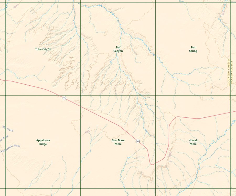
The topo map "Tuba City SE" covers the area I photographed and the hike to it. The Bat Canyon map covers Coal Mine Canyon East and Ha Ho No Geh Canyon. The other maps show the roads into the area. A merge map of all six topographic maps is also available. The maps can be downloaded in a variety of formats by clicking or right-clicking below:
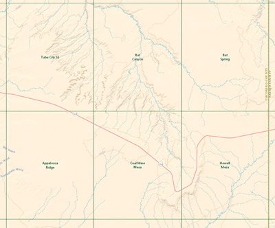
Coal Mine Canyon Index Map
| Geo Tiff/Avenza | KMZ | Oruxmaps | KMZ Decollared | Oruxmap Decollared | Avenza Decollared |
| Appaloosa Ridge | KMZ | Oruxmap | KMZ Decollared | Oruxmap Decollared | Avenza Decollared |
| Bat Canyon | KMZ | Oruxmap | KMZ Decollared | Oruxmap Decollared | Avenza Decollared |
| Bat Spring | KMZ | Oruxmap | KMZ Decollared | Oruxmap Decollared | Avenza Decollared |
| Coal Mine Mesa | KMZ | Oruxmap | KMZ Decollared | Oruxmap Decollared | Avenza Decollared |
| Howell Mesa | KMZ | Oruxmap | KMZ Decollared | Oruxmap Decollared | Avenza Decollared |
| Tuba City SE | KMZ | Oruxmap | KMZ Decollared | Oruxmap Decollared | Avenza Decollared |
| Merge of All Six Maps | NA | NA | KMZ Decollared | Oruxmap Decollared | Avenza Decollared |