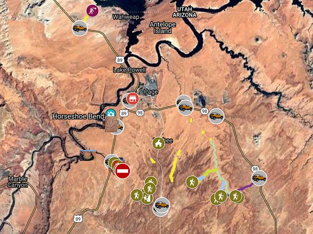
Directions to Waterholes Canyon / Bend
Waterholes Canyon is about five miles from Page and is a good early-mid afternoon destination, especially in the summer. If you are going to be in Page for the day (e.g. to photograph Antelope Canyon) you might want to follow your shoot with the Waterholes overlook of the Colorado river, followed by "The Great Wall". Just south of where Waterholes Canyon joins the Colorado River there is a bend in the Colorado, comparable to Horseshoe Bend. This bend is rarely visited; I could find no photos of it on the web. I'll call it Waterholes Bend. By hiking west along the southern rim of Waterholes Canyon you can reach a good overlook of the bend. The trailless sandy hike is approximately 2.5 miles one way. Waterholes Bend is significantly more difficult to reach than Horseshoe Bend. Good images of Waterholes Bend can be obtained at sunrise, this would require a long hike in the dark. For me mid afternoon is preferable. You need a 16mm or wider lens to shoot the whole overlook, and 14 - 15 mm would be better. A pano head would also work. A polarizer can help reduce glare off the Colorado River, just don't include much sky in your photo. You'll need to stand uncomfortably close to the edge of the cliff to get the full bend. I wouldn't get that close on a windy day. Also be sure the rock you wish to shoot from isn't undercut. If you're with someone have them anchor you by holding onto the back of your belt!
Permits
You need to have a permit from Navajo Parks and Recreation to access Waterholes Canyon. Permits can often be obtained at the entrance to Upper Antelope Canyon, or at at the Navajo Parks and Recreation office near LeChee Chapter House in Page. This office is at 36° 51.51' N, 111° 26.731' West. The office is in a small white trailer next to the LeChee Chapter House. To get to the Chapter House proceed south on Coppermine Road (Indian Route 20) 2.7 miles from the intersection of Coppermine Road and Highway 98. Make a right. Permits are also available at Horseshoe Bend Slot Canyon office 821 US-89 (near the Burger King).
The people at Navajo Parks and Recreation could not definitively state whether the permit included walking west along the rim of Waterholes Canyon. Since you are unlikely to meet anyone on your hike so you should be okay however. You'll definitely need the permit to park at the Waterholes parking area. You'll be ticketed or towed if your permit isn't visible on the dash. The permit provides in canyon access to both the east and west sides of Waterholes Canyon. The interior of the west side is technical and requires ropes/rappeling. On the east side rim is a good formation known as the "Great Wall". Access to the branch of Waterholes known as Secret Canyon is prohibited since the Waterholes permit is only valid to the powerlines, see the map for the powerlines location. A tour of Secret Canyon can be booked via Horseshoe Bend Slot Canyon Tours in Page.
Directions to Waterholes Bend / The Great Wall
From the "Walmart/McDonalds" intersection in Page proceed 4.9 miles south on Highway 89 until you reach a small parking area on the left side of 89 just before Waterholes Canyon Bridge. The bridge is clearly signed. Place your permit on the dash. To hike to the bend cross the bridge and cross Highway 89. Find a way over or under the barbed wire fence and proceed WNW to the overlook. The walk can be done is a straight line, or you can walk along the rim of Waterholes Canyon if you wish, this will add some mileage and will make the walking generally more difficult. It might provide some good photo opportunities though.
To hike to The Great Wall cross the barbed wire fence at the parking area and proceed .5 miles SE to the wall, generally following the rim of Waterholes. The wall is easily seen from a distance. The wall gets its best light right at sunset when it takes on a magnificent red glow.
To view the map in Google Maps please click anywhere on the map above.
- Click to download a KMZ file (Note - in IE Right Click and choose Save Target as).
- Click to download a KML file (Note - KML files do not include custom icons).
- Click to download a GPX file (Note - in IE Right Click and choose Save Target as).
USGS 24K Topo Maps
The topo maps White Dome and Lees Ferry cover the area of interest. The Lees Ferry map contains Waterholes Bend and the area west of Highway 89, and part of the area east of Highway 89. The Great Wall is on the border between the two maps. Secret Canyon is on the White Dome map. These maps can be downloaded in a variety of formats by clicking or right-clicking below:
| Geo Tiff/Avenza | KMZ | Oruxmaps | KMZ Decollared | Oruxmap Decollared | Avenza Decollared |
| Lees Ferry | KMZ | Oruxmap | KMZ Decollared | Oruxmap Decollared | Avenza Decollared |
| White Dome | KMZ | Oruxmap | KMZ Decollared | Oruxmap Decollared | Avenza Decollared |
| Merge of both maps | NA | NA | KMZ Decollared | Oruxmap Decollared | Avenza Decollared |