Lapland
Lapland is the extreme northern part of Europe. Parts of Lapland are in Norway, Sweden, Finland, and Russia. Lapland lies above the arctic circle and is a great place to observe the aurora in the winter.
Google Map of Lapland
Here is an overview map showing some of the northern towns in Lapland:
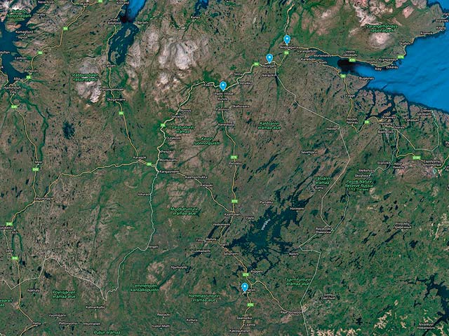
To view the map in Google Maps please click anywhere on the map above.
- Click to download a KMZ file (Note - in IE Right Click and choose Save Target as)
- Click to download a KML file (Note - KML files do not include custom icons)
- Click to download a GPX file (Note - in IE Right Click and choose Save Target as)
Finland 40K Topo Maps
Decollared topo maps are freely available for Finland from the National Land Survey of Finland. Go to the site and select Background map series and the level of detail you want. I choose a scale of 1:40,000. On the maps page click on the + sign at the left of 1:40,000 to bring up a grid of maps. You can download multiple maps at once, the screen shot below shows ten maps selected.

After you select the maps you want select Place your order and you will get an email link to your maps shortly. The maps are in png/pgw format. They can be imported into MAPC2MAPC as pgw files, make sure you select WGS_1984_UTM_ZONE_35N as your grid.
I have provided some maps for the area of Finland between Ivalo (nearest large airport) and Utsjoki on the northern border of Finland. The maps can be downloaded in a variety of formats by clicking or right clicking below:
| Geo Tiff/Avenza | KMZ | Oruxmaps |
| V43R | KMZ | Oruxmap |
| V44R | KMZ | Oruxmap |
| V51L | KMZ | Oruxmap |
| V51R | KMZ | Oruxmap |
| V52L | KMZ | Oruxmap |
| V52R | KMZ | Oruxmap |
| W43R | KMZ | Oruxmap |
| W44R | KMZ | Oruxmap |
| W51L | KMZ | Oruxmap |
| W51R | KMZ | Oruxmap |
| W52L | KMZ | Oruxmap |
| W52R | KMZ | Oruxmap |
| X43R | KMZ | Oruxmap |
| X51L | KMZ | Oruxmap |
| X51R | KMZ | Oruxmap |
| X52L | KMZ | Oruxmap |
| Merged Map | KMZ | Oruxmap |
Norway 50K Topo Maps
Decollared topo maps are freely available for Norway from the Norwegian Mapping Authority. Click on the N50 Raster (UTM33) map series and then click Add to basket. Click on the Cart icon at the upper right. Click on the Area dropdown and Select Grid will appear. Use the oveerview map and the zoom keys to select the maps you want. Several maps can be selected at once. After clicking Close the projection UTM 33 North will be automaticaly selected as will the TIFF format. Select Download and you will ge an email with a download link in a few minutes. The download file is in zip format and contains geotiff files.
I have provided maps for some of the area of Norway above Finland and below the Barents Sea. Maps can be downloaded in a variety of formats by clicking or right clicking below:
| Geo Tiff/Avenza | KMZ | Oruxmaps |
| 1189 | KMZ | Oruxmap |
| 1190 | KMZ | Oruxmap |
| 1191 | KMZ | Oruxmap |
| 1192 | KMZ | Oruxmap |
| 1214 | KMZ | Oruxmap |
| 1215 | KMZ | Oruxmap |
| 1216 | KMZ | Oruxmap |
| 1217 | KMZ | Oruxmap |
| 1237 | KMZ | Oruxmap |
| 1238 | KMZ | Oruxmap |
| 1239 | KMZ | Oruxmap |
| 1240 | KMZ | Oruxmap |
| Merged Map | KMZ | Oruxmap |