Bryce Canyon National Park and surrounding area
Below is the official Bryce Canyon National Park map as a jpeg and in three geocoded formats, as a GeoTIFF, as a KMZ file, and in Oruxmaps format. The official park map as a PDF can be found here.
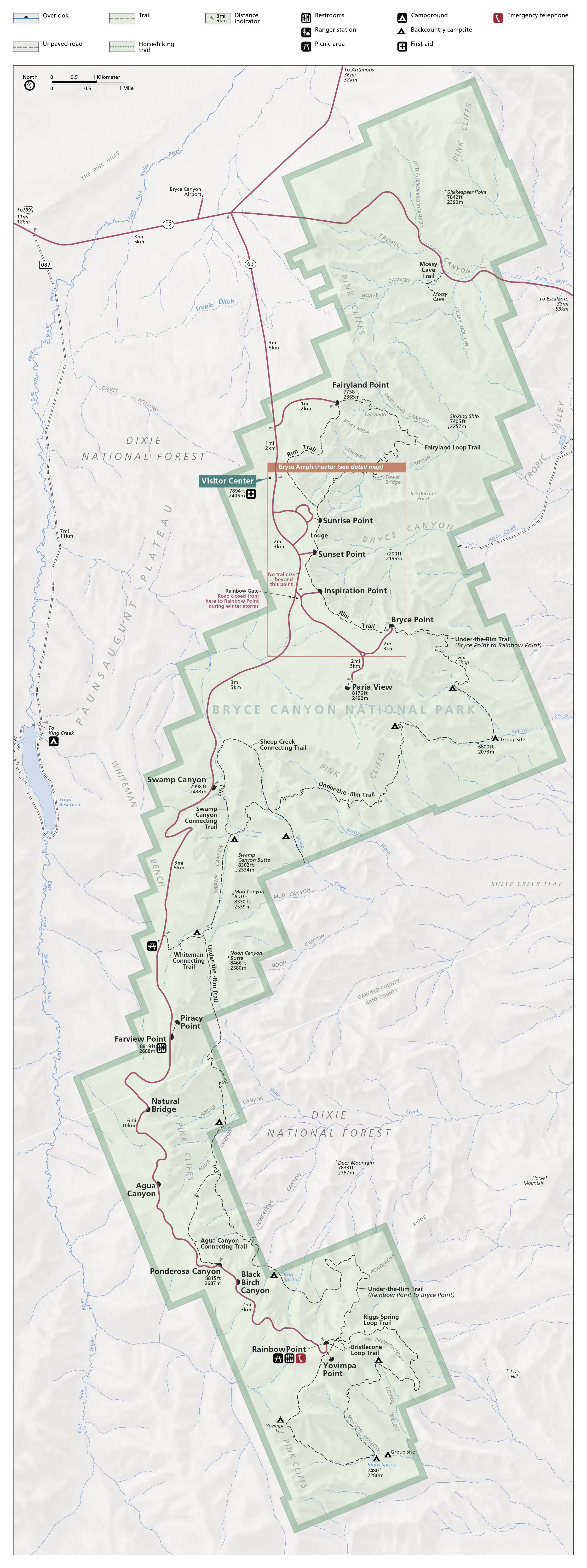
- Click to download a GeoTiff file viewable in PDF Maps
- Click to download a KMZ file viewable in Google Earth
- Click to download an Oruxmap file (Note - in IE Right Click and choose Save Target as)
When to Go
Bryce Canyon is open every day of the year. The Fee Booths and Visitor Center are closed on Christmas and Thanksgiving Day but the park is open.
The National Park Service maintains visitor statistics on their website. Data for 2020 is distorted due to the Covid-19 pandemic and should be ignored.
Visitation by month
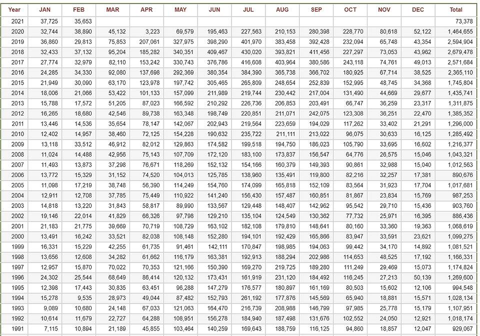
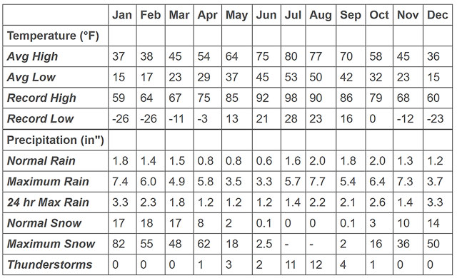
Visitation peaks in July but is high from May through September. From mid-May through September expect clear or partly cloudy skies 70% of the time. Weatherspark.com is an excellent source of climate information. In the summer, campgrounds fill by mid-day. Make lodging reservations well in advance. If you are a hiker, this period is the best time of the year to visit. Thunderstorms are common in July and August so plan to hike early in the day and watch the weather. Cooler temperatures and the chance of snow lead to thinning crowds by mid-October.
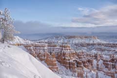
At 8,000 feet, winters in Bryce are cold and snowy. Average low temperatures from December through February are 10° F per Weatherspark.com (15° reported below by the NPS), and visitation is minimal. Winter skies are overcast or mostly cloudy forty percent of the time. These months get over a foot of snow on average. Following a snow storm, the main park road is usually closed after the turnoffs to Sunrise, Sunset, and Inspiration Points until plowing can be completed. Most trails are closed, and the open trails are icy. If you plan to hike into the canyon, consider bringing crampons. Winter activities include cross-country skiing on groomed trails, snowshoeing, ice skating, and sleigh rides. Lodging is available at Ruby's Inn on short notice, and rates are low. I find the best time to photograph Bryce Canyon is as the skies clear following a snowstorm. The contrast of the white snow on the red hoodoos is magical. Shoot the canyon from sunset or sunrise points with a normal to telephoto lens as soon as light hits the hoodoos. The snow on the hoodoos may only last a few hours, so if you plan to shoot in the winter, watch the Bryce forecast and arrive in the area the night before. Ruby's Inn has several web-cams that can be used to check snow conditions or you can call Ruby's front desk or the Bryce Canyon NPS visitor center. Go out at dawn. Bring very warm clothing, as it will be well below freezing. Keep spare camera batteries in your parka's inside pocket until shooting. I suggest you start shooting at Sunset Point followed by walking north along the rim trail 0.5 miles to Sunrise Point. At Sunrise Point there is a magnificent tree right next to the overlook.
Bryce Canyon Climate
Camping and Lodging
Bryce has two campgrounds. Sunset Campground has 50 RV sites and 50 tent sites. It is closed from November 1 to April 15. During peak season from May 20 to October 15 campsites can be reserved. North Campground is first come first served only and has 99 sites. Loops A and B are for RVs only, and C and D for tent campers only. Only Loop A is open during the winter season.
Good camping is also available outside the park. The Red Canyon Campground is $20 for a campsite and has water, toilets, and a dump station. No electric. First come, first served. The campground is normally open from May through October. Dispersed camping on USFS or BLM land is widely available in the area. The National Park service webpage on Bryce Canyon camping is an excellent source for dispersed camping rules and regulations. Camping on BLM land requires a free permit available from the BLM in Cannonville or Escalante.
Lodging is available inside the park at the Lodge at Bryce Canyon. The lodge is open from from early March until December 1st. Lodging is available just outside the park at Ruby's Inn and the Bryce Canyon Grand Hotel.
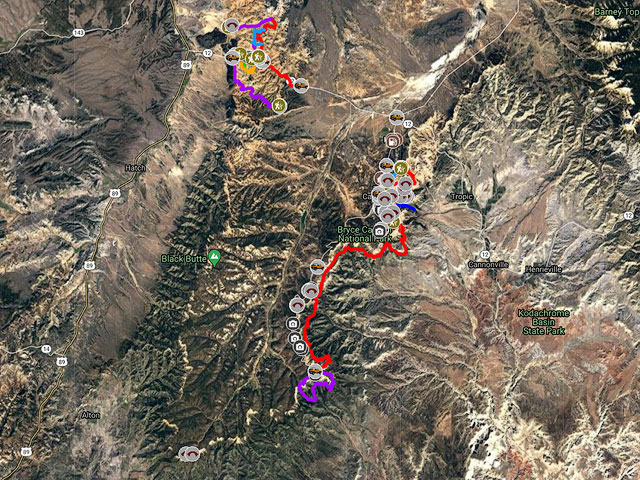
Google Map of Bryce and Red Canyons
The following map shows most of the trails in Bryce and Red Canyon, the more photogenic arches in the area, and the locations of many campsites and campgrounds.
In addition to the locations of many of the arches in Bryce Canyon I have included the greater arch dimension (GAD) which is the size of the arches opening. I have also included a photographic rating based on images I have seen. The World Arch Database (WAD) was used to select the arches and assign the ratings. My photographic ratings do not necessarily agree with those in the WAD.
Tower Bridge Arch and Bryce Natural Bridge are well known and there are many images of them on the web. There are few good images of the other arches on the map. If you like to explore they make for great destinations. Some of these arches were first reported before GPS devices were available so the locations shown are only approximate. Happy hunting!
To view the map in Google Maps please click anywhere on the map above.
- Click to download a KMZ file (Note - in IE Right Click and choose Save Target as)
- Click to download a KML file (Note - in IE Right Click and choose Save Target as)
- Click to download a GPX file (Note - in IE Right Click and choose Save Target as)
Caltopo Map showing various Points of Interest
In addition to the Google Map of Bryce Canyon I have added a Caltopo Map. Caltopo maps show land ownership which is very important if you plan to boondock. You do not want to camp on private land, and US Forest Service and BLM camping regulations are often different. Caltopo maps are also preferable for off-trail hiking since they show ten feet elevation contours and also terrain slope shading.
USGS 24K Topo Maps
Below are nine topo maps covering Bryce Canyon and the surrounding area, including Red Canyon. The last map in the table is a merged map of the entire area.
